Cedar Bluffs geodata
Cedar Bluffs (Nebraska) is a populated place; located in United States in America/Chicago (GMT-5) time zone. With population of 595 people, there are 19757 cities with bigger population in this country. Compared to other cities in United States, 69.7% of cities are located further ↓South; 74.7% of cities are located further →East and 83.6% of cities have lower elevation than Cedar Bluffs. Note1
Administrative division(s):
- Level 1: Nebraska
- Level 2: Saunders County
- Level 3: Township of North Cedar


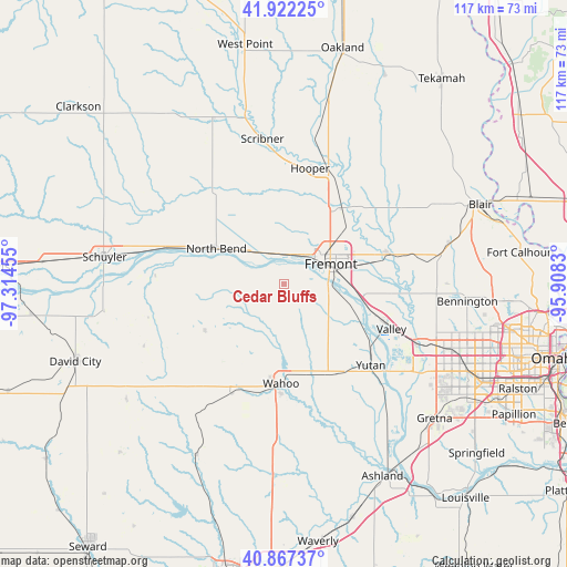
Cedar Bluffs GPS coordinates[2]
41° 23' 49.02" North, 96° 36' 41.112" West
| Map corner | latitude | longitude |
|---|---|---|
| Upper-left | 41.92225°, | -97.31455° |
| Center: | 41.39695°, | -96.61142° |
| Lower-right: | 40.86737°, | -95.9083° |
| Map W x H: | 117.3×117.3 km | = 72.9×72.9mi |
| max Lat: | 71.29058° ⇑30.3% North |
| Cedar Bluffs: | 41.39695° |
| min Lat: | ⇓69.7% South 19.06759° |
| min Long | Cedar Bluffs | max Long |
| -171.73463° | -96.61142° | -66.98998° |
| W 25.3%⇐ | ⇒74.7% E |
Elevation
Elevation of Cedar Bluffs is 398 m = 1306 ft, and this is 103.2 m = 339 ft above average elevation for this country.
| Max E: |
3189 m = 10463 ft | 16.4% |
| Cedar Bluffs | 398 m 1306 ft | |
| Avg. | 294.8 m = 967 ft | |
Min E: |
-60 m = -197 ft | 83.6% |
See also: United States elevation on elevation.city.
Geographical zone
Cedar Bluffs is located in North temperate zone (between Tropic of Cancer and the Arctic Circle). Distance of this Northern Tropic circle is 1997 km =1240.9 mi to South.| Distance of | km | miles | from Cedar Bluffs |
|---|---|---|---|
| North Pole | 5404.2 | 3358 | to North |
| Arctic Circle | 2798.3 | 1738.8 | to North |
| Tropic Cancer | 1997 | 1240.9 | to South |
| Equator | 4602.9 | 2860.1 | to South |


Nearby cities:
15 places around Cedar Bluffs: (largest is in red/bold)
• Arlington
22.6 km =14 mi,  74°
74°
• Bennington
38 km =23.6 mi,  95°
95°
• Ceresco
37.9 km =23.5 mi,  184°
184°
• Elkhorn
33.8 km =21 mi,  111°
111°
• Fremont
10.3 km =6.4 mi, 66°
• Hooper
24.3 km =15.1 mi,  12°
12°
• Mead
21.5 km =13.4 mi,  151°
151°
• North Bend
15.8 km =9.8 mi,  297°
297°
• Schuyler
37.8 km =23.5 mi,  278°
278°
• Scribner
30.3 km =18.8 mi,  351°
351°
• Valley
24 km =14.9 mi, 112°
• Valparaiso
39.6 km =24.6 mi,  207°
207°
• Wahoo
20.6 km =12.8 mi, 182°
• Waterloo
29.8 km =18.5 mi, 114°
• Yutan
24.6 km =15.3 mi,  133°
133°
Sources, notices
• [Note1] Compared only with cities in United States existing in our database
• [Src1] Map data: © OpenStreetMap contributors (CC-BY-SA)
• [Src2] Other city data from geonames.org with taken over terms of usage.
• [Src3] Geographical zone / Annual Mean Temperature by Robert A. Rohde @ Wikipedia
