Fremont geodata
Fremont (Nebraska) is a seat of a second-order administrative division; located in United States in America/Chicago (GMT-5) time zone. With population of 26,474 people, there are 1894 cities with bigger population in this country. Compared to other cities in United States, 70.1% of cities are located further ↓South; 74.5% of cities are located further →East and 81.1% of cities have lower elevation than Fremont. Note1


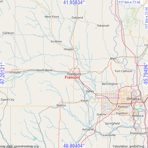
Fremont GPS coordinates[2]
41° 25' 59.988" North, 96° 29' 53.088" West
| Map corner | latitude | longitude |
|---|---|---|
| Upper-left | 41.95834°, | -97.20121° |
| Center: | 41.43333°, | -96.49808° |
| Lower-right: | 40.90404°, | -95.79496° |
| Map W x H: | 117.2×117.2 km | = 72.8×72.8mi |
| max Lat: | 71.29058° ⇑29.9% North |
| Fremont: | 41.43333° |
| min Lat: | ⇓70.1% South 19.06759° |
| min Long | Fremont | max Long |
| -171.73463° | -96.49808° | -66.98998° |
| W 25.5%⇐ | ⇒74.5% E |
Elevation
Elevation of Fremont is 366 m = 1201 ft, and this is 71.2 m = 234 ft above average elevation for this country.
| Max E: |
3189 m = 10463 ft | 18.9% |
| Fremont | 366 m 1201 ft | |
| Avg. | 294.8 m = 967 ft | |
Min E: |
-60 m = -197 ft | 81.1% |
See also: United States elevation on elevation.city.
Geographical zone
Fremont is located in North temperate zone (between Tropic of Cancer and the Arctic Circle). Distance of this Northern Tropic circle is 2001 km =1243.4 mi to South.| Distance of | km | miles | from Fremont |
|---|---|---|---|
| North Pole | 5400.1 | 3355.5 | to North |
| Arctic Circle | 2794.2 | 1736.2 | to North |
| Tropic Cancer | 2001 | 1243.4 | to South |
| Equator | 4607 | 2862.7 | to South |


Nearby cities:
15 places around Fremont: (largest is in red/bold)
• Arlington
12.4 km =7.7 mi,  80°
80°
• Bennington
29.4 km =18.3 mi,  105°
105°
• Blair
33.4 km =20.8 mi,  68°
68°
• Boys Town
36.1 km =22.4 mi,  122°
122°
• Cedar Bluffs
10.3 km =6.4 mi,  246°
246°
• Elkhorn
27.4 km =17 mi,  126°
126°
• Gretna
39 km =24.2 mi,  146°
146°
• Hooper
20.1 km =12.5 mi,  348°
348°
• Mead
22.9 km =14.2 mi,  177°
177°
• North Bend
23.7 km =14.7 mi,  277°
277°
• Scribner
29.5 km =18.3 mi,  331°
331°
• Valley
18.4 km =11.4 mi,  136°
136°
• Wahoo
26.7 km =16.6 mi,  202°
202°
• Waterloo
24.1 km =15 mi, 132°
• Yutan
22.6 km =14 mi,  158°
158°
Sources, notices
• [Note1] Compared only with cities in United States existing in our database
• [Src1] Map data: © OpenStreetMap contributors (CC-BY-SA)
• [Src2] Other city data from geonames.org with taken over terms of usage.
• [Src3] Geographical zone / Annual Mean Temperature by Robert A. Rohde @ Wikipedia
