Yutan geodata
Yutan (Nebraska) is a populated place; located in United States in America/Chicago (GMT-5) time zone. With population of 1,212 people, there are 15063 cities with bigger population in this country. Compared to other cities in United States, 68.2% of cities are located further ↓South; 74.2% of cities are located further →East and 80.5% of cities have lower elevation than Yutan. Note1


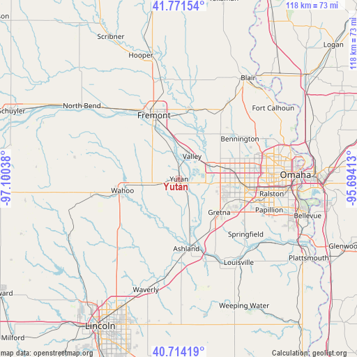
Yutan GPS coordinates[2]
41° 14' 42" North, 96° 23' 50.1" West
| Map corner | latitude | longitude |
|---|---|---|
| Upper-left | 41.77154°, | -97.10038° |
| Center: | 41.245°, | -96.39725° |
| Lower-right: | 40.71419°, | -95.69413° |
| Map W x H: | 117.6×117.6 km | = 73.1×73.1mi |
| max Lat: | 71.29058° ⇑31.8% North |
| Yutan: | 41.245° |
| min Lat: | ⇓68.2% South 19.06759° |
| min Long | Yutan | max Long |
| -171.73463° | -96.39725° | -66.98998° |
| W 25.8%⇐ | ⇒74.2% E |
Elevation
Elevation of Yutan is 358 m = 1175 ft, and this is 63.2 m = 207 ft above average elevation for this country.
| Max E: |
3189 m = 10463 ft | 19.5% |
| Yutan | 358 m 1175 ft | |
| Avg. | 294.8 m = 967 ft | |
Min E: |
-60 m = -197 ft | 80.5% |
See also: United States elevation on elevation.city.
Geographical zone
Yutan is located in North temperate zone (between Tropic of Cancer and the Arctic Circle). Distance of this Northern Tropic circle is 1980.1 km =1230.4 mi to South.| Distance of | km | miles | from Yutan |
|---|---|---|---|
| North Pole | 5421 | 3368.5 | to North |
| Arctic Circle | 2815.2 | 1749.3 | to North |
| Tropic Cancer | 1980.1 | 1230.4 | to South |
| Equator | 4586 | 2849.6 | to South |


Nearby cities:
15 places around Yutan: (largest is in red/bold)
• Arlington
23.4 km =14.5 mi,  9°
9°
• Ashland
23 km =14.3 mi,  173°
173°
• Bennington
24 km =14.9 mi,  56°
56°
• Boys Town
22.2 km =13.8 mi,  85°
85°
• Cedar Bluffs
24.6 km =15.3 mi,  313°
313°
• Ceresco
29.4 km =18.3 mi,  224°
224°
• Chalco
21.7 km =13.5 mi,  108°
108°
• Elkhorn
14.4 km =8.9 mi,  71°
71°
• Fremont
22.6 km =14 mi,  338°
338°
• Gretna
17.5 km =10.9 mi,  131°
131°
• Mead
7.8 km =4.8 mi,  255°
255°
• Springfield
28.5 km =17.7 mi, 129°
• Valley
8.7 km =5.4 mi,  29°
29°
• Wahoo
19 km =11.8 mi, 258°
• Waterloo
10.4 km =6.5 mi, 63°
Sources, notices
• [Note1] Compared only with cities in United States existing in our database
• [Src1] Map data: © OpenStreetMap contributors (CC-BY-SA)
• [Src2] Other city data from geonames.org with taken over terms of usage.
• [Src3] Geographical zone / Annual Mean Temperature by Robert A. Rohde @ Wikipedia
