Cheektowaga geodata
Cheektowaga (New York) is a populated place; located in United States in America/New_York (GMT-4) time zone. With population of 75,178 people, there are 539 cities with bigger population in this country. Compared to other cities in United States, 82.5% of cities are located further ↓South; 76.4% of cities are located further ←West and 50% of cities have lower elevation than Cheektowaga. Note1


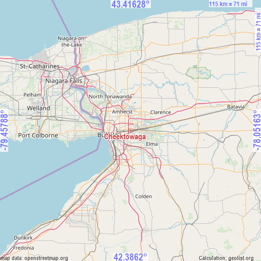
Cheektowaga GPS coordinates[2]
42° 54' 12.204" North, 78° 45' 17.1" West
| Map corner | latitude | longitude |
|---|---|---|
| Upper-left | 43.41628°, | -79.45788° |
| Center: | 42.90339°, | -78.75475° |
| Lower-right: | 42.3862°, | -78.05163° |
| Map W x H: | 114.5×114.5 km | = 71.1×71.1mi |
| max Lat: | 71.29058° ⇑17.5% North |
| Cheektowaga: | 42.90339° |
| min Lat: | ⇓82.5% South 19.06759° |
| min Long | Cheektowaga | max Long |
| -171.73463° | -78.75475° | -66.98998° |
| W 76.4%⇐ | ⇒23.6% E |
Elevation
Elevation of Cheektowaga is 198 m = 650 ft, and this is 96.8 m = 318 ft below average elevation for this country.
| Max E: |
3189 m = 10463 ft | 50% |
| Avg. | 294.8 m = 967 ft | |
| Cheektowaga | 198 m = 650 ft | |
Min E: |
-60 m = -197 ft | 50% |
See also: Cheektowaga elevation on elevation.city.
Geographical zone
Cheektowaga is located in North temperate zone (between Tropic of Cancer and the Arctic Circle). Distance of this Northern Tropic circle is 2164.5 km =1345 mi to South.| Distance of | km | miles | from Cheektowaga |
|---|---|---|---|
| North Pole | 5236.7 | 3253.9 | to North |
| Arctic Circle | 2630.8 | 1634.7 | to North |
| Tropic Cancer | 2164.5 | 1345 | to South |
| Equator | 4770.4 | 2964.2 | to South |


Nearby cities:
15 places around Cheektowaga: (largest is in red/bold)
• Amherst
9.1 km =5.7 mi,  336°
336°
• Blasdell
13.1 km =8.1 mi,  205°
205°
• Buffalo
10.2 km =6.3 mi,  259°
259°
• Depew
5.1 km =3.2 mi,  89°
89°
• Eggertsville
7.8 km =4.8 mi,  329°
329°
• Elma Center
12.7 km =7.9 mi,  130°
130°
• Harris Hill
9.3 km =5.8 mi,  42°
42°
• Kenmore
11.7 km =7.3 mi,  306°
306°
• Lackawanna
10.3 km =6.4 mi, 212°
• Lancaster
6.9 km =4.3 mi, 92°
• Orchard Park
15.1 km =9.4 mi,  176°
176°
• Sloan
3.4 km =2.1 mi,  250°
250°
• Town Line
14.5 km =9 mi,  95°
95°
• West Seneca
7 km =4.3 mi, 211°
• Williamsville
6.9 km =4.3 mi,  11°
11°
Sources, notices
• [Note1] Compared only with cities in United States existing in our database
• [Src1] Map data: © OpenStreetMap contributors (CC-BY-SA)
• [Src2] Other city data from geonames.org with taken over terms of usage.
• [Src3] Geographical zone / Annual Mean Temperature by Robert A. Rohde @ Wikipedia
