Canarsie geodata
Canarsie (New York) is a populated place; located in United States in America/New_York (GMT-4) time zone. With population of 87,366 people, there are 433 cities with bigger population in this country. Compared to other cities in United States, 60.7% of cities are located further ↓South; 91.2% of cities are located further ←West and 97.4% of cities have higher elevation than Canarsie. Note1


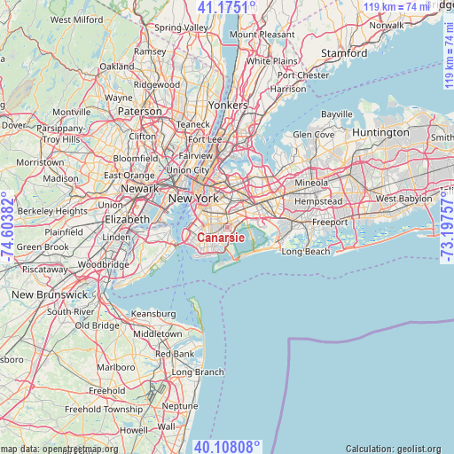
Canarsie GPS coordinates[2]
40° 38' 37.392" North, 73° 54' 2.484" West
| Map corner | latitude | longitude |
|---|---|---|
| Upper-left | 41.1751°, | -74.60382° |
| Center: | 40.64372°, | -73.90069° |
| Lower-right: | 40.10808°, | -73.19757° |
| Map W x H: | 118.6×118.6 km | = 73.7×73.7mi |
| max Lat: | 71.29058° ⇑39.3% North |
| Canarsie: | 40.64372° |
| min Lat: | ⇓60.7% South 19.06759° |
| min Long | Canarsie | max Long |
| -171.73463° | -73.90069° | -66.98998° |
| W 91.2%⇐ | ⇒8.8% E |
Elevation
Elevation of Canarsie is 6 m = 20 ft, and this is 288.8 m = 948 ft below average elevation for this country.
| Max E: |
3189 m = 10463 ft | 97.4% |
| Avg. | 294.8 m = 967 ft | |
| Canarsie | 6 m = 20 ft | |
Min E: |
-60 m = -197 ft | 2.6% |
See also: Canarsie elevation on elevation.city.
Geographical zone
Canarsie is located in North temperate zone (between Tropic of Cancer and the Arctic Circle). Distance of this Northern Tropic circle is 1913.2 km =1188.8 mi to South.| Distance of | km | miles | from Canarsie |
|---|---|---|---|
| North Pole | 5487.9 | 3410 | to North |
| Arctic Circle | 2882 | 1790.8 | to North |
| Tropic Cancer | 1913.2 | 1188.8 | to South |
| Equator | 4519.2 | 2808.1 | to South |


Nearby cities:
15 places around Canarsie: (largest is in red/bold)
• Bergen Beach
2.6 km =1.6 mi,  191°
191°
• Brooklyn
4.2 km =2.6 mi,  279°
279°
• Brownsville
2.5 km =1.6 mi,  319°
319°
• Bushwick
5.8 km =3.6 mi,  344°
344°
• Cypress Hills
3.8 km =2.4 mi,  12°
12°
• East Flatbush
2.7 km =1.7 mi,  293°
293°
• East New York
3 km =1.9 mi,  31°
31°
• Flatbush
5 km =3.1 mi, 280°
• Flatlands
3.8 km =2.4 mi,  229°
229°
• Glendale
6.5 km =4 mi, 10°
• Howard Beach
5.7 km =3.5 mi,  73°
73°
• Kensington
5.9 km =3.7 mi,  272°
272°
• Ozone Park
6 km =3.7 mi,  52°
52°
• Ridgewood
6.3 km =3.9 mi,  356°
356°
• Woodhaven
6.2 km =3.9 mi,  35°
35°
Sources, notices
• [Note1] Compared only with cities in United States existing in our database
• [Src1] Map data: © OpenStreetMap contributors (CC-BY-SA)
• [Src2] Other city data from geonames.org with taken over terms of usage.
• [Src3] Geographical zone / Annual Mean Temperature by Robert A. Rohde @ Wikipedia
