Ridgewood geodata
Ridgewood (New York) is a section of populated place; located in United States in America/New_York (GMT-4) time zone. With population of 69,317 people, there are 600 cities with bigger population in this country. Compared to other cities in United States, 61.6% of cities are located further ↓South; 91.2% of cities are located further ←West and 87.4% of cities have higher elevation than Ridgewood. Note1


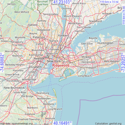
Ridgewood GPS coordinates[2]
40° 42' 0.36" North, 73° 54' 20.484" West
| Map corner | latitude | longitude |
|---|---|---|
| Upper-left | 41.23103°, | -74.60882° |
| Center: | 40.7001°, | -73.90569° |
| Lower-right: | 40.16491°, | -73.20257° |
| Map W x H: | 118.5×118.5 km | = 73.6×73.6mi |
| max Lat: | 71.29058° ⇑38.4% North |
| Ridgewood: | 40.7001° |
| min Lat: | ⇓61.6% South 19.06759° |
| min Long | Ridgewood | max Long |
| -171.73463° | -73.90569° | -66.98998° |
| W 91.2%⇐ | ⇒8.8% E |
Elevation
Elevation of Ridgewood is 22 m = 72 ft, and this is 272.8 m = 895 ft below average elevation for this country.
| Max E: |
3189 m = 10463 ft | 87.4% |
| Avg. | 294.8 m = 967 ft | |
| Ridgewood | 22 m = 72 ft | |
Min E: |
-60 m = -197 ft | 12.6% |
See also: Ridgewood elevation on elevation.city.
Geographical zone
Ridgewood is located in North temperate zone (between Tropic of Cancer and the Arctic Circle). Distance of this Northern Tropic circle is 1919.5 km =1192.7 mi to South.| Distance of | km | miles | from Ridgewood |
|---|---|---|---|
| North Pole | 5481.6 | 3406.1 | to North |
| Arctic Circle | 2875.7 | 1786.9 | to North |
| Tropic Cancer | 1919.5 | 1192.7 | to South |
| Equator | 4525.4 | 2812 | to South |


Nearby cities:
15 places around Ridgewood: (largest is in red/bold)
• Brownsville
4.5 km =2.8 mi,  195°
195°
• Bushwick
1.3 km =0.8 mi,  239°
239°
• Cypress Hills
2.8 km =1.7 mi,  154°
154°
• East New York
4.2 km =2.6 mi, 152°
• Elmhurst
4.7 km =2.9 mi,  30°
30°
• Forest Hills
5 km =3.1 mi,  69°
69°
• Glendale
1.6 km =1 mi,  84°
84°
• Greenpoint
4.6 km =2.9 mi,  304°
304°
• Maspeth
2.6 km =1.6 mi,  347°
347°
• Middle Village
2.8 km =1.7 mi,  48°
48°
• Rego Park
5.3 km =3.3 mi,  56°
56°
• Sunnyside
5.1 km =3.2 mi,  330°
330°
• Williamsburg
4.3 km =2.7 mi,  291°
291°
• Woodhaven
4.2 km =2.6 mi,  106°
106°
• Woodside
5 km =3.1 mi,  0°
0°
Sources, notices
• [Note1] Compared only with cities in United States existing in our database
• [Src1] Map data: © OpenStreetMap contributors (CC-BY-SA)
• [Src2] Other city data from geonames.org with taken over terms of usage.
• [Src3] Geographical zone / Annual Mean Temperature by Robert A. Rohde @ Wikipedia
