Bushwick geodata
Bushwick (New York) is a populated place; located in United States in America/New_York (GMT-4) time zone. With population of 112,620 people, there are 289 cities with bigger population in this country. Compared to other cities in United States, 61.5% of cities are located further ↓South; 91.1% of cities are located further ←West and 93% of cities have higher elevation than Bushwick. Note1


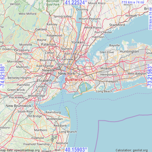
Bushwick GPS coordinates[2]
40° 41' 39.372" North, 73° 55' 7.5" West
| Map corner | latitude | longitude |
|---|---|---|
| Upper-left | 41.22524°, | -74.62188° |
| Center: | 40.69427°, | -73.91875° |
| Lower-right: | 40.15903°, | -73.21563° |
| Map W x H: | 118.6×118.6 km | = 73.7×73.7mi |
| max Lat: | 71.29058° ⇑38.5% North |
| Bushwick: | 40.69427° |
| min Lat: | ⇓61.5% South 19.06759° |
| min Long | Bushwick | max Long |
| -171.73463° | -73.91875° | -66.98998° |
| W 91.1%⇐ | ⇒8.9% E |
Elevation
Elevation of Bushwick is 11 m = 36 ft, and this is 283.8 m = 931 ft below average elevation for this country.
| Max E: |
3189 m = 10463 ft | 93% |
| Avg. | 294.8 m = 967 ft | |
| Bushwick | 11 m = 36 ft | |
Min E: |
-60 m = -197 ft | 7% |
See also: Bushwick elevation on elevation.city.
Geographical zone
Bushwick is located in North temperate zone (between Tropic of Cancer and the Arctic Circle). Distance of this Northern Tropic circle is 1918.9 km =1192.3 mi to South.| Distance of | km | miles | from Bushwick |
|---|---|---|---|
| North Pole | 5482.3 | 3406.5 | to North |
| Arctic Circle | 2876.4 | 1787.3 | to North |
| Tropic Cancer | 1918.9 | 1192.3 | to South |
| Equator | 4524.8 | 2811.6 | to South |


Nearby cities:
15 places around Bushwick: (largest is in red/bold)
• Brooklyn
5.6 km =3.5 mi,  207°
207°
• Brownsville
3.7 km =2.3 mi,  181°
181°
• Cypress Hills
3 km =1.9 mi,  129°
129°
• East Flatbush
4.6 km =2.9 mi,  192°
192°
• East New York
4.3 km =2.7 mi, 134°
• Elmhurst
5.8 km =3.6 mi,  36°
36°
• Glendale
2.8 km =1.7 mi,  73°
73°
• Greenpoint
4.3 km =2.7 mi,  320°
320°
• Maspeth
3.3 km =2.1 mi,  9°
9°
• Middle Village
4 km =2.5 mi,  51°
51°
• Ridgewood
1.3 km =0.8 mi,  59°
59°
• Sunnyside
5.3 km =3.3 mi,  344°
344°
• Williamsburg
3.7 km =2.3 mi,  307°
307°
• Woodhaven
5.2 km =3.2 mi,  96°
96°
• Woodside
5.8 km =3.6 mi, 11°
Sources, notices
• [Note1] Compared only with cities in United States existing in our database
• [Src1] Map data: © OpenStreetMap contributors (CC-BY-SA)
• [Src2] Other city data from geonames.org with taken over terms of usage.
• [Src3] Geographical zone / Annual Mean Temperature by Robert A. Rohde @ Wikipedia
