Clarence Center geodata
Clarence Center (New York) is a populated place; located in United States in America/New_York (GMT-4) time zone. With population of 2,257 people, there are 11198 cities with bigger population in this country. Compared to other cities in United States, 83.4% of cities are located further ↓South; 76.7% of cities are located further ←West and 50.3% of cities have higher elevation than Clarence Center. Note1


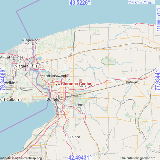
Clarence Center GPS coordinates[2]
43° 0' 38.196" North, 78° 38' 15.108" West
| Map corner | latitude | longitude |
|---|---|---|
| Upper-left | 43.5226°, | -79.34066° |
| Center: | 43.01061°, | -78.63753° |
| Lower-right: | 42.49431°, | -77.93441° |
| Map W x H: | 114.3×114.3 km | = 71×71mi |
| max Lat: | 71.29058° ⇑16.6% North |
| Clarence Center: | 43.01061° |
| min Lat: | ⇓83.4% South 19.06759° |
| min Long | Clarence Center | max Long |
| -171.73463° | -78.63753° | -66.98998° |
| W 76.7%⇐ | ⇒23.3% E |
Elevation
Elevation of Clarence Center is 197 m = 646 ft, and this is 97.8 m = 321 ft below average elevation for this country.
| Max E: |
3189 m = 10463 ft | 50.3% |
| Avg. | 294.8 m = 967 ft | |
| Clarence Center | 197 m = 646 ft | |
Min E: |
-60 m = -197 ft | 49.7% |
See also: United States elevation on elevation.city.
Geographical zone
Clarence Center is located in North temperate zone (between Tropic of Cancer and the Arctic Circle). Distance of this Northern Tropic circle is 2176.4 km =1352.4 mi to South.| Distance of | km | miles | from Clarence Center |
|---|---|---|---|
| North Pole | 5224.7 | 3246.5 | to North |
| Arctic Circle | 2618.8 | 1627.2 | to North |
| Tropic Cancer | 2176.4 | 1352.4 | to South |
| Equator | 4782.3 | 2971.6 | to South |


Nearby cities:
15 places around Clarence Center: (largest is in red/bold)
• Akron
11.6 km =7.2 mi,  84°
84°
• Alden
17.1 km =10.6 mi,  136°
136°
• Amherst
13.7 km =8.5 mi,  254°
254°
• Cheektowaga
15.3 km =9.5 mi,  218°
218°
• Clarence
5.3 km =3.3 mi, 135°
• Depew
12.7 km =7.9 mi,  200°
200°
• Eggertsville
14.5 km =9 mi, 248°
• Harris Hill
6 km =3.7 mi,  212°
212°
• Lancaster
12.5 km =7.8 mi,  192°
192°
• Lockport
18.3 km =11.4 mi,  346°
346°
• Rapids
9.8 km =6.1 mi,  358°
358°
• Sloan
18.2 km =11.3 mi, 224°
• South Lockport
16.2 km =10.1 mi,  342°
342°
• Town Line
14.2 km =8.8 mi,  159°
159°
• Williamsville
9.7 km =6 mi,  237°
237°
Sources, notices
• [Note1] Compared only with cities in United States existing in our database
• [Src1] Map data: © OpenStreetMap contributors (CC-BY-SA)
• [Src2] Other city data from geonames.org with taken over terms of usage.
• [Src3] Geographical zone / Annual Mean Temperature by Robert A. Rohde @ Wikipedia
