Country Knolls geodata
Country Knolls (New York) is a populated place; located in United States in America/New_York (GMT-4) time zone. With population of 2,224 people, there are 11282 cities with bigger population in this country. Compared to other cities in United States, 82.7% of cities are located further ↓South; 91.6% of cities are located further ←West and 71.1% of cities have higher elevation than Country Knolls. Note1
Administrative division(s):
- Level 1: New York
- Level 2: Saratoga County
- Level 3: Town of Clifton Park


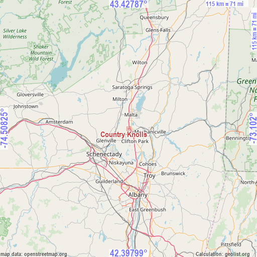
Country Knolls GPS coordinates[2]
42° 54' 54.288" North, 73° 48' 18.432" West
| Map corner | latitude | longitude |
|---|---|---|
| Upper-left | 43.42787°, | -74.50825° |
| Center: | 42.91508°, | -73.80512° |
| Lower-right: | 42.39799°, | -73.102° |
| Map W x H: | 114.5×114.5 km | = 71.1×71.1mi |
| max Lat: | 71.29058° ⇑17.3% North |
| Country Knolls: | 42.91508° |
| min Lat: | ⇓82.7% South 19.06759° |
| min Long | Country Knolls | max Long |
| -171.73463° | -73.80512° | -66.98998° |
| W 91.6%⇐ | ⇒8.4% E |
Elevation
Elevation of Country Knolls is 94 m = 308 ft, and this is 200.8 m = 659 ft below average elevation for this country.
| Max E: |
3189 m = 10463 ft | 71.1% |
| Avg. | 294.8 m = 967 ft | |
| Country Knolls | 94 m = 308 ft | |
Min E: |
-60 m = -197 ft | 28.9% |
See also: United States elevation on elevation.city.
Geographical zone
Country Knolls is located in North temperate zone (between Tropic of Cancer and the Arctic Circle). Distance of this Northern Tropic circle is 2165.8 km =1345.8 mi to South.| Distance of | km | miles | from Country Knolls |
|---|---|---|---|
| North Pole | 5235.4 | 3253.1 | to North |
| Arctic Circle | 2629.5 | 1633.9 | to North |
| Tropic Cancer | 2165.8 | 1345.8 | to South |
| Equator | 4771.7 | 2965 | to South |


Nearby cities:
15 places around Country Knolls: (largest is in red/bold)
• Ballston Spa
10.2 km =6.3 mi,  339°
339°
• Cohoes
17.8 km =11.1 mi,  151°
151°
• East Glenville
10.3 km =6.4 mi,  257°
257°
• Latham
19.1 km =11.9 mi,  168°
168°
• Mechanicville
9.7 km =6 mi,  98°
98°
• Milton
13.7 km =8.5 mi, 343°
• Niskayuna
15.4 km =9.6 mi,  192°
192°
• North Ballston Spa
12.2 km =7.6 mi, 342°
• Round Lake
2.9 km =1.8 mi,  25°
25°
• Saratoga Springs
18.8 km =11.7 mi,  5°
5°
• Schaghticoke
18 km =11.2 mi, 95°
• Schenectady
15.7 km =9.8 mi,  224°
224°
• Scotia
16.3 km =10.1 mi,  232°
232°
• Stillwater
12.6 km =7.8 mi,  78°
78°
• Waterford
17 km =10.6 mi,  143°
143°
Sources, notices
• [Note1] Compared only with cities in United States existing in our database
• [Src1] Map data: © OpenStreetMap contributors (CC-BY-SA)
• [Src2] Other city data from geonames.org with taken over terms of usage.
• [Src3] Geographical zone / Annual Mean Temperature by Robert A. Rohde @ Wikipedia
