Schenectady geodata
Schenectady (New York) is a seat of a second-order administrative division; located in United States in America/New_York (GMT-4) time zone. With population of 65,305 people, there are 658 cities with bigger population in this country. Compared to other cities in United States, 82% of cities are located further ↓South; 91% of cities are located further ←West and 73.9% of cities have higher elevation than Schenectady. Note1
Administrative division(s):
- Level 1: New York
- Level 2: Schenectady County
- Level 3: City of Schenectady


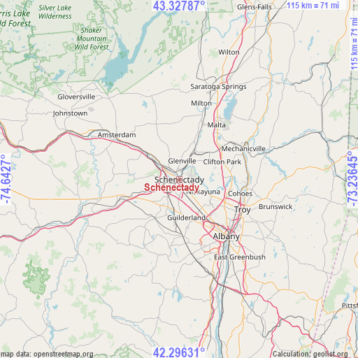
Schenectady GPS coordinates[2]
42° 48' 51.264" North, 73° 56' 22.452" West
| Map corner | latitude | longitude |
|---|---|---|
| Upper-left | 43.32787°, | -74.6427° |
| Center: | 42.81424°, | -73.93957° |
| Lower-right: | 42.29631°, | -73.23645° |
| Map W x H: | 114.7×114.7 km | = 71.3×71.3mi |
| max Lat: | 71.29058° ⇑18% North |
| Schenectady: | 42.81424° |
| min Lat: | ⇓82% South 19.06759° |
| min Long | Schenectady | max Long |
| -171.73463° | -73.93957° | -66.98998° |
| W 91%⇐ | ⇒9% E |
Elevation
Elevation of Schenectady is 78 m = 256 ft, and this is 216.8 m = 711 ft below average elevation for this country.
| Max E: |
3189 m = 10463 ft | 73.9% |
| Avg. | 294.8 m = 967 ft | |
| Schenectady | 78 m = 256 ft | |
Min E: |
-60 m = -197 ft | 26.1% |
See also: Schenectady elevation on elevation.city.
Geographical zone
Schenectady is located in North temperate zone (between Tropic of Cancer and the Arctic Circle). Distance of this Northern Tropic circle is 2154.6 km =1338.8 mi to South.| Distance of | km | miles | from Schenectady |
|---|---|---|---|
| North Pole | 5246.6 | 3260.1 | to North |
| Arctic Circle | 2640.7 | 1640.9 | to North |
| Tropic Cancer | 2154.6 | 1338.8 | to South |
| Equator | 4760.5 | 2958 | to South |


Nearby cities:
15 places around Schenectady: (largest is in red/bold)
• Altamont
14.8 km =9.2 mi,  211°
211°
• Colonie
13.8 km =8.6 mi,  141°
141°
• Country Knolls
15.7 km =9.8 mi,  44°
44°
• East Glenville
9 km =5.6 mi,  6°
6°
• Latham
16.5 km =10.3 mi,  116°
116°
• Mariaville Lake
15.5 km =9.6 mi,  274°
274°
• McKownville
16.3 km =10.1 mi,  152°
152°
• Niskayuna
8.6 km =5.3 mi, 116°
• Roessleville
17.1 km =10.6 mi, 140°
• Rotterdam
4 km =2.5 mi,  220°
220°
• Round Lake
18.4 km =11.4 mi, 41°
• Scotia
2.4 km =1.5 mi,  303°
303°
• Voorheesville
17.8 km =11.1 mi,  177°
177°
• West Albany
19.6 km =12.2 mi, 137°
• Westmere
14.9 km =9.3 mi,  157°
157°
Sources, notices
• [Note1] Compared only with cities in United States existing in our database
• [Src1] Map data: © OpenStreetMap contributors (CC-BY-SA)
• [Src2] Other city data from geonames.org with taken over terms of usage.
• [Src3] Geographical zone / Annual Mean Temperature by Robert A. Rohde @ Wikipedia
