East Glenville geodata
East Glenville (New York) is a populated place; located in United States in America/New_York (GMT-4) time zone. With population of 6,616 people, there are 6039 cities with bigger population in this country. Compared to other cities in United States, 82.5% of cities are located further ↓South; 91% of cities are located further ←West and 67.5% of cities have higher elevation than East Glenville. Note1
Administrative division(s):
- Level 1: New York
- Level 2: Schenectady County
- Level 3: Town of Glenville


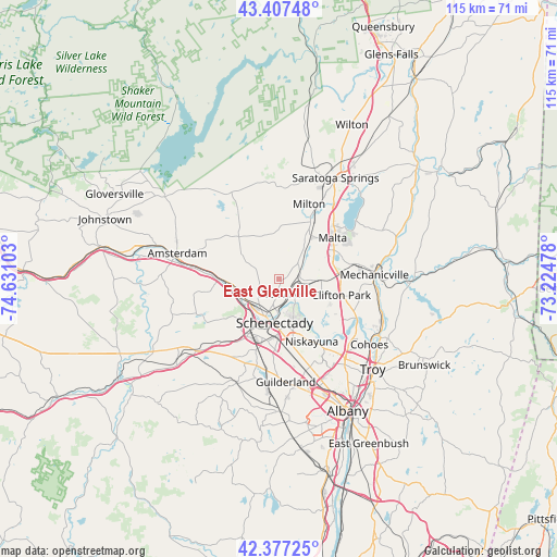
East Glenville GPS coordinates[2]
42° 53' 40.272" North, 73° 55' 40.44" West
| Map corner | latitude | longitude |
|---|---|---|
| Upper-left | 43.40748°, | -74.63103° |
| Center: | 42.89452°, | -73.9279° |
| Lower-right: | 42.37725°, | -73.22478° |
| Map W x H: | 114.6×114.5 km | = 71.2×71.1mi |
| max Lat: | 71.29058° ⇑17.5% North |
| East Glenville: | 42.89452° |
| min Lat: | ⇓82.5% South 19.06759° |
| min Long | East Glenville | max Long |
| -171.73463° | -73.9279° | -66.98998° |
| W 91%⇐ | ⇒9% E |
Elevation
Elevation of East Glenville is 115 m = 377 ft, and this is 179.8 m = 590 ft below average elevation for this country.
| Max E: |
3189 m = 10463 ft | 67.5% |
| Avg. | 294.8 m = 967 ft | |
| East Glenville | 115 m = 377 ft | |
Min E: |
-60 m = -197 ft | 32.5% |
See also: United States elevation on elevation.city.
Geographical zone
East Glenville is located in North temperate zone (between Tropic of Cancer and the Arctic Circle). Distance of this Northern Tropic circle is 2163.5 km =1344.3 mi to South.| Distance of | km | miles | from East Glenville |
|---|---|---|---|
| North Pole | 5237.6 | 3254.5 | to North |
| Arctic Circle | 2631.8 | 1635.3 | to North |
| Tropic Cancer | 2163.5 | 1344.3 | to South |
| Equator | 4769.4 | 2963.6 | to South |


Nearby cities:
15 places around East Glenville: (largest is in red/bold)
• Amsterdam
21.8 km =13.5 mi,  283°
283°
• Ballston Spa
13.5 km =8.4 mi,  28°
28°
• Colonie
21.1 km =13.1 mi,  158°
158°
• Country Knolls
10.3 km =6.4 mi,  77°
77°
• Hagaman
20.2 km =12.6 mi,  296°
296°
• Latham
21.4 km =13.3 mi,  139°
139°
• Mariaville Lake
18.1 km =11.2 mi,  244°
244°
• Mechanicville
19.6 km =12.2 mi,  87°
87°
• Milton
16.6 km =10.3 mi,  21°
21°
• Niskayuna
14.4 km =8.9 mi,  152°
152°
• North Ballston Spa
15.3 km =9.5 mi, 24°
• Rotterdam
12.5 km =7.8 mi,  196°
196°
• Round Lake
12.3 km =7.6 mi,  66°
66°
• Schenectady
9 km =5.6 mi,  186°
186°
• Scotia
8.1 km =5 mi, 201°
Sources, notices
• [Note1] Compared only with cities in United States existing in our database
• [Src1] Map data: © OpenStreetMap contributors (CC-BY-SA)
• [Src2] Other city data from geonames.org with taken over terms of usage.
• [Src3] Geographical zone / Annual Mean Temperature by Robert A. Rohde @ Wikipedia
