Gowanda geodata
Gowanda (New York) is a populated place; located in United States in America/New_York (GMT-4) time zone. With population of 2,636 people, there are 10319 cities with bigger population in this country. Compared to other cities in United States, 79.5% of cities are located further ↓South; 75.9% of cities are located further ←West and 59% of cities have lower elevation than Gowanda. Note1


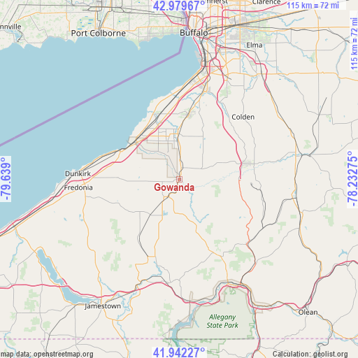
Gowanda GPS coordinates[2]
42° 27' 47.232" North, 78° 56' 9.132" West
| Map corner | latitude | longitude |
|---|---|---|
| Upper-left | 42.97967°, | -79.639° |
| Center: | 42.46312°, | -78.93587° |
| Lower-right: | 41.94227°, | -78.23275° |
| Map W x H: | 115.3×115.3 km | = 71.6×71.6mi |
| max Lat: | 71.29058° ⇑20.5% North |
| Gowanda: | 42.46312° |
| min Lat: | ⇓79.5% South 19.06759° |
| min Long | Gowanda | max Long |
| -171.73463° | -78.93587° | -66.98998° |
| W 75.9%⇐ | ⇒24.1% E |
Elevation
Elevation of Gowanda is 235 m = 771 ft, and this is 59.8 m = 196 ft below average elevation for this country.
| Max E: |
3189 m = 10463 ft | 41% |
| Avg. | 294.8 m = 967 ft | |
| Gowanda | 235 m = 771 ft | |
Min E: |
-60 m = -197 ft | 59% |
See also: United States elevation on elevation.city.
Geographical zone
Gowanda is located in North temperate zone (between Tropic of Cancer and the Arctic Circle). Distance of this Northern Tropic circle is 2115.5 km =1314.5 mi to South.| Distance of | km | miles | from Gowanda |
|---|---|---|---|
| North Pole | 5285.6 | 3284.3 | to North |
| Arctic Circle | 2679.7 | 1665.1 | to North |
| Tropic Cancer | 2115.5 | 1314.5 | to South |
| Equator | 4721.5 | 2933.8 | to South |


Nearby cities:
15 places around Gowanda: (largest is in red/bold)
• Angola
20.9 km =13 mi,  338°
338°
• Angola on the Lake
23.2 km =14.4 mi, 336°
• Boston
24.6 km =15.3 mi,  41°
41°
• Cattaraugus
15.9 km =9.9 mi,  159°
159°
• Eden
21.3 km =13.2 mi,  8°
8°
• Forestville
19.8 km =12.3 mi,  271°
271°
• Lake Erie Beach
20.9 km =13 mi,  329°
329°
• Little Valley
25.7 km =16 mi, 155°
• North Boston
28 km =17.4 mi,  27°
27°
• North Collins
14.7 km =9.1 mi,  358°
358°
• Silver Creek
21 km =13 mi,  295°
295°
• South Dayton
14.7 km =9.1 mi,  221°
221°
• Springville
22.6 km =14 mi,  77°
77°
• Sunset Bay
19.6 km =12.2 mi, 304°
• West Valley
27.6 km =17.1 mi,  104°
104°
Sources, notices
• [Note1] Compared only with cities in United States existing in our database
• [Src1] Map data: © OpenStreetMap contributors (CC-BY-SA)
• [Src2] Other city data from geonames.org with taken over terms of usage.
• [Src3] Geographical zone / Annual Mean Temperature by Robert A. Rohde @ Wikipedia
