Sunset Bay geodata
Sunset Bay (New York) is a populated place; located in United States in America/New_York (GMT-4) time zone. With population of 660 people, there are 19073 cities with bigger population in this country. Compared to other cities in United States, 80.3% of cities are located further ↓South; 75.5% of cities are located further ←West and 55.1% of cities have higher elevation than Sunset Bay. Note1


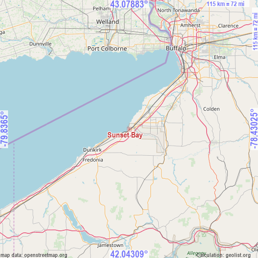
Sunset Bay GPS coordinates[2]
42° 33' 47.196" North, 79° 8' 0.132" West
| Map corner | latitude | longitude |
|---|---|---|
| Upper-left | 43.07883°, | -79.8365° |
| Center: | 42.56311°, | -79.13337° |
| Lower-right: | 42.04309°, | -78.43025° |
| Map W x H: | 115.2×115.2 km | = 71.6×71.6mi |
| max Lat: | 71.29058° ⇑19.7% North |
| Sunset Bay: | 42.56311° |
| min Lat: | ⇓80.3% South 19.06759° |
| min Long | Sunset Bay | max Long |
| -171.73463° | -79.13337° | -66.98998° |
| W 75.5%⇐ | ⇒24.5% E |
Elevation
Elevation of Sunset Bay is 180 m = 591 ft, and this is 114.8 m = 377 ft below average elevation for this country.
| Max E: |
3189 m = 10463 ft | 55.1% |
| Avg. | 294.8 m = 967 ft | |
| Sunset Bay | 180 m = 591 ft | |
Min E: |
-60 m = -197 ft | 44.9% |
See also: United States elevation on elevation.city.
Geographical zone
Sunset Bay is located in North temperate zone (between Tropic of Cancer and the Arctic Circle). Distance of this Northern Tropic circle is 2126.7 km =1321.5 mi to South.| Distance of | km | miles | from Sunset Bay |
|---|---|---|---|
| North Pole | 5274.5 | 3277.4 | to North |
| Arctic Circle | 2668.6 | 1658.2 | to North |
| Tropic Cancer | 2126.7 | 1321.5 | to South |
| Equator | 4732.6 | 2940.7 | to South |


Nearby cities:
15 places around Sunset Bay: (largest is in red/bold)
• Angola
12 km =7.5 mi,  45°
45°
• Angola on the Lake
12.3 km =7.6 mi,  34°
34°
• Brocton
31.8 km =19.8 mi,  232°
232°
• Cassadaga
28.3 km =17.6 mi,  210°
210°
• Dunkirk
18.9 km =11.7 mi,  240°
240°
• Eden
21.7 km =13.5 mi,  62°
62°
• Forestville
11.1 km =6.9 mi,  198°
198°
• Fredonia
21.2 km =13.2 mi, 229°
• Gowanda
19.6 km =12.2 mi,  124°
124°
• Hamburg
30.1 km =18.7 mi, 55°
• Lake Erie Beach
8.7 km =5.4 mi,  38°
38°
• North Collins
16.1 km =10 mi,  77°
77°
• Silver Creek
3.4 km =2.1 mi, 232°
• South Dayton
23 km =14.3 mi,  163°
163°
• Wanakah
27.7 km =17.2 mi, 42°
Sources, notices
• [Note1] Compared only with cities in United States existing in our database
• [Src1] Map data: © OpenStreetMap contributors (CC-BY-SA)
• [Src2] Other city data from geonames.org with taken over terms of usage.
• [Src3] Geographical zone / Annual Mean Temperature by Robert A. Rohde @ Wikipedia
