South Dayton geodata
South Dayton (New York) is a populated place; located in United States in America/New_York (GMT-4) time zone. With population of 594 people, there are 19769 cities with bigger population in this country. Compared to other cities in United States, 78.6% of cities are located further ↓South; 75.6% of cities are located further ←West and 83.7% of cities have lower elevation than South Dayton. Note1


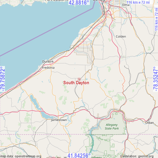
South Dayton GPS coordinates[2]
42° 21' 51.228" North, 79° 3' 20.124" West
| Map corner | latitude | longitude |
|---|---|---|
| Upper-left | 42.8816°, | -79.75872° |
| Center: | 42.36423°, | -79.05559° |
| Lower-right: | 41.84256°, | -78.35247° |
| Map W x H: | 115.5×115.5 km | = 71.8×71.8mi |
| max Lat: | 71.29058° ⇑21.4% North |
| South Dayton: | 42.36423° |
| min Lat: | ⇓78.6% South 19.06759° |
| min Long | South Dayton | max Long |
| -171.73463° | -79.05559° | -66.98998° |
| W 75.6%⇐ | ⇒24.4% E |
Elevation
Elevation of South Dayton is 400 m = 1312 ft, and this is 105.2 m = 345 ft above average elevation for this country.
| Max E: |
3189 m = 10463 ft | 16.3% |
| South Dayton | 400 m 1312 ft | |
| Avg. | 294.8 m = 967 ft | |
Min E: |
-60 m = -197 ft | 83.7% |
See also: United States elevation on elevation.city.
Geographical zone
South Dayton is located in North temperate zone (between Tropic of Cancer and the Arctic Circle). Distance of this Northern Tropic circle is 2104.5 km =1307.7 mi to South.| Distance of | km | miles | from South Dayton |
|---|---|---|---|
| North Pole | 5296.6 | 3291.2 | to North |
| Arctic Circle | 2690.7 | 1671.9 | to North |
| Tropic Cancer | 2104.5 | 1307.7 | to South |
| Equator | 4710.5 | 2927 | to South |


Nearby cities:
15 places around South Dayton: (largest is in red/bold)
• Cassadaga
21 km =13 mi,  263°
263°
• Cattaraugus
15.9 km =9.9 mi,  104°
104°
• Dunkirk
26.2 km =16.3 mi,  299°
299°
• East Randolph
23.1 km =14.4 mi,  157°
157°
• Falconer
29.7 km =18.5 mi,  203°
203°
• Forestville
15.3 km =9.5 mi,  319°
319°
• Fredonia
24.2 km =15 mi,  290°
290°
• Gowanda
14.7 km =9.1 mi,  41°
41°
• Lake Erie Beach
28.9 km =18 mi,  358°
358°
• Little Valley
24 km =14.9 mi,  121°
121°
• North Collins
27.4 km =17 mi,  20°
20°
• Randolph
23.4 km =14.5 mi, 163°
• Silver Creek
22 km =13.7 mi,  335°
335°
• Sinclairville
20.1 km =12.5 mi,  236°
236°
• Sunset Bay
23 km =14.3 mi, 343°
Sources, notices
• [Note1] Compared only with cities in United States existing in our database
• [Src1] Map data: © OpenStreetMap contributors (CC-BY-SA)
• [Src2] Other city data from geonames.org with taken over terms of usage.
• [Src3] Geographical zone / Annual Mean Temperature by Robert A. Rohde @ Wikipedia
