Mayville geodata
Mayville (New York) is a seat of a second-order administrative division; located in United States in America/New_York (GMT-4) time zone. With population of 1,669 people, there are 13009 cities with bigger population in this country. Compared to other cities in United States, 77.8% of cities are located further ↓South; 74.9% of cities are located further ←West and 86% of cities have lower elevation than Mayville. Note1
Administrative division(s):
- Level 1: New York
- Level 2: Chautauqua County
- Level 3: Town of Chautauqua


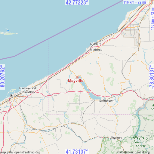
Mayville GPS coordinates[2]
42° 15' 14.22" North, 79° 30' 16.164" West
| Map corner | latitude | longitude |
|---|---|---|
| Upper-left | 42.77223°, | -80.20762° |
| Center: | 42.25395°, | -79.50449° |
| Lower-right: | 41.73137°, | -78.80137° |
| Map W x H: | 115.7×115.7 km | = 71.9×71.9mi |
| max Lat: | 71.29058° ⇑22.2% North |
| Mayville: | 42.25395° |
| min Lat: | ⇓77.8% South 19.06759° |
| min Long | Mayville | max Long |
| -171.73463° | -79.50449° | -66.98998° |
| W 74.9%⇐ | ⇒25.1% E |
Elevation
Elevation of Mayville is 444 m = 1457 ft, and this is 149.2 m = 490 ft above average elevation for this country.
| Max E: |
3189 m = 10463 ft | 14% |
| Mayville | 444 m 1457 ft | |
| Avg. | 294.8 m = 967 ft | |
Min E: |
-60 m = -197 ft | 86% |
See also: United States elevation on elevation.city.
Geographical zone
Mayville is located in North temperate zone (between Tropic of Cancer and the Arctic Circle). Distance of this Northern Tropic circle is 2092.3 km =1300.1 mi to South.| Distance of | km | miles | from Mayville |
|---|---|---|---|
| North Pole | 5308.9 | 3298.8 | to North |
| Arctic Circle | 2703 | 1679.6 | to North |
| Tropic Cancer | 2092.3 | 1300.1 | to South |
| Equator | 4698.2 | 2919.3 | to South |


Nearby cities:
15 places around Mayville: (largest is in red/bold)
• Brocton
15.9 km =9.9 mi,  19°
19°
• Cassadaga
18.9 km =11.7 mi,  57°
57°
• Celoron
24.3 km =15.1 mi,  131°
131°
• Clymer
27.9 km =17.3 mi,  201°
201°
• Dunkirk
28.7 km =17.8 mi,  29°
29°
• Fredonia
25.1 km =15.6 mi, 34°
• Jamestown
28.2 km =17.5 mi, 128°
• Jamestown West
26 km =16.2 mi, 134°
• Lakewood
21.8 km =13.5 mi,  139°
139°
• North East
27.5 km =17.1 mi,  261°
261°
• Portland
14.3 km =8.9 mi,  12°
12°
• Ripley
17 km =10.6 mi,  274°
274°
• Sherman
12.9 km =8 mi,  215°
215°
• Sinclairville
20.3 km =12.6 mi,  86°
86°
• Westfield
9.7 km =6 mi,  321°
321°
Sources, notices
• [Note1] Compared only with cities in United States existing in our database
• [Src1] Map data: © OpenStreetMap contributors (CC-BY-SA)
• [Src2] Other city data from geonames.org with taken over terms of usage.
• [Src3] Geographical zone / Annual Mean Temperature by Robert A. Rohde @ Wikipedia
