Cassadaga geodata
Cassadaga (New York) is a populated place; located in United States in America/New_York (GMT-4) time zone. With population of 611 people, there are 19576 cities with bigger population in this country. Compared to other cities in United States, 78.5% of cities are located further ↓South; 75.2% of cities are located further ←West and 84.4% of cities have lower elevation than Cassadaga. Note1


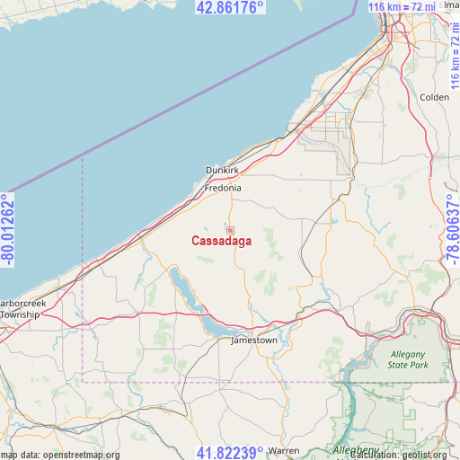
Cassadaga GPS coordinates[2]
42° 20' 39.192" North, 79° 18' 34.164" West
| Map corner | latitude | longitude |
|---|---|---|
| Upper-left | 42.86176°, | -80.01262° |
| Center: | 42.34422°, | -79.30949° |
| Lower-right: | 41.82239°, | -78.60637° |
| Map W x H: | 115.6×115.6 km | = 71.8×71.8mi |
| max Lat: | 71.29058° ⇑21.5% North |
| Cassadaga: | 42.34422° |
| min Lat: | ⇓78.5% South 19.06759° |
| min Long | Cassadaga | max Long |
| -171.73463° | -79.30949° | -66.98998° |
| W 75.2%⇐ | ⇒24.8% E |
Elevation
Elevation of Cassadaga is 412 m = 1352 ft, and this is 117.2 m = 385 ft above average elevation for this country.
| Max E: |
3189 m = 10463 ft | 15.6% |
| Cassadaga | 412 m 1352 ft | |
| Avg. | 294.8 m = 967 ft | |
Min E: |
-60 m = -197 ft | 84.4% |
See also: United States elevation on elevation.city.
Geographical zone
Cassadaga is located in North temperate zone (between Tropic of Cancer and the Arctic Circle). Distance of this Northern Tropic circle is 2102.3 km =1306.3 mi to South.| Distance of | km | miles | from Cassadaga |
|---|---|---|---|
| North Pole | 5298.8 | 3292.5 | to North |
| Arctic Circle | 2692.9 | 1673.3 | to North |
| Tropic Cancer | 2102.3 | 1306.3 | to South |
| Equator | 4708.2 | 2925.5 | to South |


Nearby cities:
15 places around Cassadaga: (largest is in red/bold)
• Brocton
11.9 km =7.4 mi,  294°
294°
• Celoron
26.2 km =16.3 mi,  175°
175°
• Dunkirk
15.2 km =9.4 mi,  352°
352°
• Falconer
26.7 km =16.6 mi,  159°
159°
• Forestville
17.6 km =10.9 mi,  38°
38°
• Fredonia
10.8 km =6.7 mi, 350°
• Jamestown
28.2 km =17.5 mi,  167°
167°
• Lakewood
26.8 km =16.7 mi, 184°
• Mayville
18.9 km =11.7 mi,  237°
237°
• Portland
13.6 km =8.5 mi, 286°
• Silver Creek
25.1 km =15.6 mi,  27°
27°
• Sinclairville
9.9 km =6.2 mi,  154°
154°
• South Dayton
21 km =13 mi,  83°
83°
• Sunset Bay
28.3 km =17.6 mi, 30°
• Westfield
22.2 km =13.8 mi,  263°
263°
Sources, notices
• [Note1] Compared only with cities in United States existing in our database
• [Src1] Map data: © OpenStreetMap contributors (CC-BY-SA)
• [Src2] Other city data from geonames.org with taken over terms of usage.
• [Src3] Geographical zone / Annual Mean Temperature by Robert A. Rohde @ Wikipedia
