Johnstown geodata
Johnstown (New York) is a seat of a second-order administrative division; located in United States in America/New_York (GMT-4) time zone. With population of 8,345 people, there are 5110 cities with bigger population in this country. Compared to other cities in United States, 83.3% of cities are located further ↓South; 88.8% of cities are located further ←West and 52.5% of cities have lower elevation than Johnstown. Note1


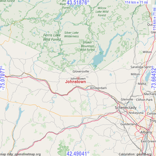
Johnstown GPS coordinates[2]
43° 0' 24.264" North, 74° 22' 3.504" West
| Map corner | latitude | longitude |
|---|---|---|
| Upper-left | 43.51876°, | -75.07077° |
| Center: | 43.00674°, | -74.36764° |
| Lower-right: | 42.49041°, | -73.66452° |
| Map W x H: | 114.3×114.3 km | = 71×71mi |
| max Lat: | 71.29058° ⇑16.7% North |
| Johnstown: | 43.00674° |
| min Lat: | ⇓83.3% South 19.06759° |
| min Long | Johnstown | max Long |
| -171.73463° | -74.36764° | -66.98998° |
| W 88.8%⇐ | ⇒11.2% E |
Elevation
Elevation of Johnstown is 208 m = 682 ft, and this is 86.8 m = 285 ft below average elevation for this country.
| Max E: |
3189 m = 10463 ft | 47.5% |
| Avg. | 294.8 m = 967 ft | |
| Johnstown | 208 m = 682 ft | |
Min E: |
-60 m = -197 ft | 52.5% |
See also: United States elevation on elevation.city.
Geographical zone
Johnstown is located in North temperate zone (between Tropic of Cancer and the Arctic Circle). Distance of this Northern Tropic circle is 2176 km =1352.1 mi to South.| Distance of | km | miles | from Johnstown |
|---|---|---|---|
| North Pole | 5225.2 | 3246.8 | to North |
| Arctic Circle | 2619.3 | 1627.6 | to North |
| Tropic Cancer | 2176 | 1352.1 | to South |
| Equator | 4781.9 | 2971.3 | to South |


Nearby cities:
15 places around Johnstown: (largest is in red/bold)
• Amsterdam
16.4 km =10.2 mi,  117°
117°
• Broadalbin
15.1 km =9.4 mi,  67°
67°
• Canajoharie
20.1 km =12.5 mi,  235°
235°
• Caroga Lake
17.3 km =10.7 mi,  327°
327°
• Fonda
5.9 km =3.7 mi,  187°
187°
• Fort Plain
22.4 km =13.9 mi,  248°
248°
• Fultonville
6.6 km =4.1 mi,  181°
181°
• Gloversville
5.5 km =3.4 mi,  20°
20°
• Hagaman
18 km =11.2 mi,  101°
101°
• Mayfield
13.7 km =8.5 mi,  37°
37°
• Nelliston
21.5 km =13.4 mi, 248°
• Palatine Bridge
19.9 km =12.4 mi, 237°
• Perth
14.2 km =8.8 mi,  85°
85°
• Tribes Hill
8.8 km =5.5 mi,  130°
130°
• Wellsville
16.5 km =10.3 mi,  151°
151°
Sources, notices
• [Note1] Compared only with cities in United States existing in our database
• [Src1] Map data: © OpenStreetMap contributors (CC-BY-SA)
• [Src2] Other city data from geonames.org with taken over terms of usage.
• [Src3] Geographical zone / Annual Mean Temperature by Robert A. Rohde @ Wikipedia
