Broadalbin geodata
Broadalbin (New York) is a populated place; located in United States in America/New_York (GMT-4) time zone. With population of 1,303 people, there are 14583 cities with bigger population in this country. Compared to other cities in United States, 83.7% of cities are located further ↓South; 89.5% of cities are located further ←West and 62.1% of cities have lower elevation than Broadalbin. Note1


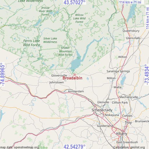
Broadalbin GPS coordinates[2]
43° 3' 31.248" North, 74° 11' 47.472" West
| Map corner | latitude | longitude |
|---|---|---|
| Upper-left | 43.57027°, | -74.89965° |
| Center: | 43.05868°, | -74.19652° |
| Lower-right: | 42.54279°, | -73.4934° |
| Map W x H: | 114.2×114.2 km | = 71×71mi |
| max Lat: | 71.29058° ⇑16.3% North |
| Broadalbin: | 43.05868° |
| min Lat: | ⇓83.7% South 19.06759° |
| min Long | Broadalbin | max Long |
| -171.73463° | -74.19652° | -66.98998° |
| W 89.5%⇐ | ⇒10.5% E |
Elevation
Elevation of Broadalbin is 249 m = 817 ft, and this is 45.8 m = 150 ft below average elevation for this country.
| Max E: |
3189 m = 10463 ft | 37.9% |
| Avg. | 294.8 m = 967 ft | |
| Broadalbin | 249 m = 817 ft | |
Min E: |
-60 m = -197 ft | 62.1% |
See also: United States elevation on elevation.city.
Geographical zone
Broadalbin is located in North temperate zone (between Tropic of Cancer and the Arctic Circle). Distance of this Northern Tropic circle is 2181.8 km =1355.7 mi to South.| Distance of | km | miles | from Broadalbin |
|---|---|---|---|
| North Pole | 5219.4 | 3243.2 | to North |
| Arctic Circle | 2613.5 | 1624 | to North |
| Tropic Cancer | 2181.8 | 1355.7 | to South |
| Equator | 4787.7 | 2974.9 | to South |


Nearby cities:
15 places around Broadalbin: (largest is in red/bold)
• Amsterdam
13.4 km =8.3 mi,  177°
177°
• Caroga Lake
24.7 km =15.3 mi,  290°
290°
• Edinburg
19.6 km =12.2 mi,  22°
22°
• Fonda
18.7 km =11.6 mi,  231°
231°
• Fultonville
18.8 km =11.7 mi, 228°
• Gloversville
12 km =7.5 mi,  266°
266°
• Hagaman
10.1 km =6.3 mi,  158°
158°
• Johnstown
15.1 km =9.4 mi,  247°
247°
• Mariaville Lake
26.6 km =16.5 mi,  168°
168°
• Mayfield
7.5 km =4.7 mi,  312°
312°
• Milton
28.1 km =17.5 mi,  95°
95°
• Northville
18.7 km =11.6 mi,  6°
6°
• Perth
4.6 km =2.9 mi, 177°
• Tribes Hill
13.6 km =8.5 mi,  212°
212°
• Wellsville
21.2 km =13.2 mi,  196°
196°
Sources, notices
• [Note1] Compared only with cities in United States existing in our database
• [Src1] Map data: © OpenStreetMap contributors (CC-BY-SA)
• [Src2] Other city data from geonames.org with taken over terms of usage.
• [Src3] Geographical zone / Annual Mean Temperature by Robert A. Rohde @ Wikipedia
