Mayfield geodata
Mayfield (New York) is a populated place; located in United States in America/New_York (GMT-4) time zone. With population of 803 people, there are 17786 cities with bigger population in this country. Compared to other cities in United States, 84.1% of cities are located further ↓South; 89.2% of cities are located further ←West and 64.8% of cities have lower elevation than Mayfield. Note1


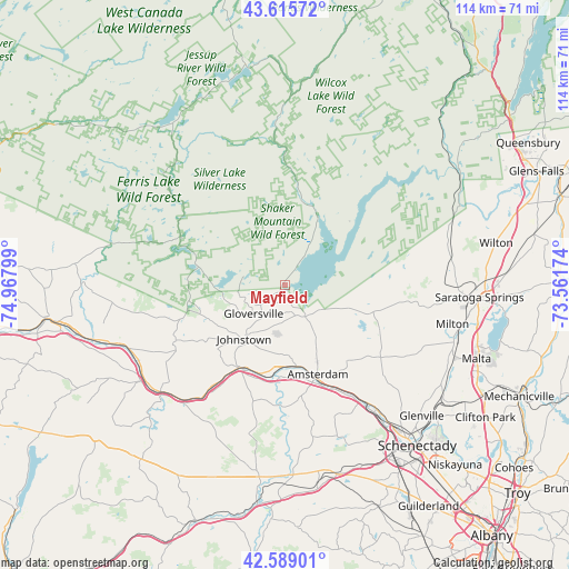
Mayfield GPS coordinates[2]
43° 6' 16.272" North, 74° 15' 53.496" West
| Map corner | latitude | longitude |
|---|---|---|
| Upper-left | 43.61572°, | -74.96799° |
| Center: | 43.10452°, | -74.26486° |
| Lower-right: | 42.58901°, | -73.56174° |
| Map W x H: | 114.2×114.2 km | = 71×71mi |
| max Lat: | 71.29058° ⇑15.9% North |
| Mayfield: | 43.10452° |
| min Lat: | ⇓84.1% South 19.06759° |
| min Long | Mayfield | max Long |
| -171.73463° | -74.26486° | -66.98998° |
| W 89.2%⇐ | ⇒10.8% E |
Elevation
Elevation of Mayfield is 261 m = 856 ft, and this is 33.8 m = 111 ft below average elevation for this country.
| Max E: |
3189 m = 10463 ft | 35.2% |
| Avg. | 294.8 m = 967 ft | |
| Mayfield | 261 m = 856 ft | |
Min E: |
-60 m = -197 ft | 64.8% |
See also: United States elevation on elevation.city.
Geographical zone
Mayfield is located in North temperate zone (between Tropic of Cancer and the Arctic Circle). Distance of this Northern Tropic circle is 2186.9 km =1358.9 mi to South.| Distance of | km | miles | from Mayfield |
|---|---|---|---|
| North Pole | 5214.3 | 3240 | to North |
| Arctic Circle | 2608.4 | 1620.8 | to North |
| Tropic Cancer | 2186.9 | 1358.9 | to South |
| Equator | 4792.8 | 2978.1 | to South |


Nearby cities:
15 places around Mayfield: (largest is in red/bold)
• Amsterdam
19.5 km =12.1 mi,  161°
161°
• Broadalbin
7.5 km =4.7 mi,  132°
132°
• Caroga Lake
17.9 km =11.1 mi,  281°
281°
• Edinburg
18.4 km =11.4 mi,  45°
45°
• Fonda
19 km =11.8 mi,  208°
208°
• Fultonville
19.4 km =12.1 mi, 206°
• Gloversville
8.6 km =5.3 mi,  228°
228°
• Hagaman
17.2 km =10.7 mi,  147°
147°
• Johnstown
13.7 km =8.5 mi,  217°
217°
• Mariaville Lake
33 km =20.5 mi, 160°
• Northville
15.4 km =9.6 mi,  29°
29°
• Palatine Bridge
33.1 km =20.6 mi, 229°
• Perth
11.3 km =7 mi, 149°
• Tribes Hill
16.7 km =10.4 mi,  185°
185°
• Wellsville
25.4 km =15.8 mi,  181°
181°
Sources, notices
• [Note1] Compared only with cities in United States existing in our database
• [Src1] Map data: © OpenStreetMap contributors (CC-BY-SA)
• [Src2] Other city data from geonames.org with taken over terms of usage.
• [Src3] Geographical zone / Annual Mean Temperature by Robert A. Rohde @ Wikipedia
