Tribes Hill geodata
Tribes Hill (New York) is a populated place; located in United States in America/New_York (GMT-4) time zone. With population of 1,003 people, there are 16262 cities with bigger population in this country. Compared to other cities in United States, 82.9% of cities are located further ↓South; 89.1% of cities are located further ←West and 64.7% of cities have higher elevation than Tribes Hill. Note1


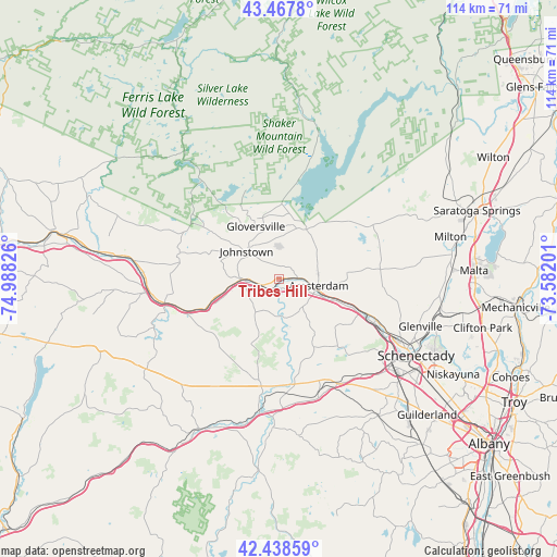
Tribes Hill GPS coordinates[2]
42° 57' 19.26" North, 74° 17' 6.468" West
| Map corner | latitude | longitude |
|---|---|---|
| Upper-left | 43.4678°, | -74.98826° |
| Center: | 42.95535°, | -74.28513° |
| Lower-right: | 42.43859°, | -73.58201° |
| Map W x H: | 114.4×114.4 km | = 71.1×71.1mi |
| max Lat: | 71.29058° ⇑17.1% North |
| Tribes Hill: | 42.95535° |
| min Lat: | ⇓82.9% South 19.06759° |
| min Long | Tribes Hill | max Long |
| -171.73463° | -74.28513° | -66.98998° |
| W 89.1%⇐ | ⇒10.9% E |
Elevation
Elevation of Tribes Hill is 130 m = 427 ft, and this is 164.8 m = 541 ft below average elevation for this country.
| Max E: |
3189 m = 10463 ft | 64.7% |
| Avg. | 294.8 m = 967 ft | |
| Tribes Hill | 130 m = 427 ft | |
Min E: |
-60 m = -197 ft | 35.3% |
See also: United States elevation on elevation.city.
Geographical zone
Tribes Hill is located in North temperate zone (between Tropic of Cancer and the Arctic Circle). Distance of this Northern Tropic circle is 2170.3 km =1348.6 mi to South.| Distance of | km | miles | from Tribes Hill |
|---|---|---|---|
| North Pole | 5230.9 | 3250.3 | to North |
| Arctic Circle | 2625 | 1631.1 | to North |
| Tropic Cancer | 2170.3 | 1348.6 | to South |
| Equator | 4776.2 | 2967.8 | to South |


Nearby cities:
15 places around Tribes Hill: (largest is in red/bold)
• Amsterdam
8.1 km =5 mi,  103°
103°
• Broadalbin
13.6 km =8.5 mi,  32°
32°
• Canajoharie
24 km =14.9 mi,  256°
256°
• Caroga Lake
25.8 km =16 mi,  321°
321°
• Fonda
7.4 km =4.6 mi,  269°
269°
• Fultonville
7 km =4.3 mi, 263°
• Gloversville
11.8 km =7.3 mi,  336°
336°
• Hagaman
11.1 km =6.9 mi,  78°
78°
• Johnstown
8.8 km =5.5 mi,  310°
310°
• Mariaville Lake
19.3 km =12 mi,  138°
138°
• Mayfield
16.7 km =10.4 mi,  5°
5°
• Nelliston
26.8 km =16.7 mi, 265°
• Palatine Bridge
24 km =14.9 mi, 258°
• Perth
10.1 km =6.3 mi,  46°
46°
• Wellsville
8.9 km =5.5 mi,  173°
173°
Sources, notices
• [Note1] Compared only with cities in United States existing in our database
• [Src1] Map data: © OpenStreetMap contributors (CC-BY-SA)
• [Src2] Other city data from geonames.org with taken over terms of usage.
• [Src3] Geographical zone / Annual Mean Temperature by Robert A. Rohde @ Wikipedia
