Owego geodata
Owego (New York) is a seat of a second-order administrative division; located in United States in America/New_York (GMT-4) time zone. With population of 3,736 people, there are 8540 cities with bigger population in this country. Compared to other cities in United States, 76.6% of cities are located further ↓South; 83.3% of cities are located further ←West and 62.6% of cities have lower elevation than Owego. Note1


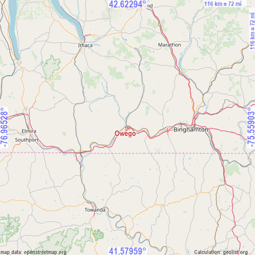
Owego GPS coordinates[2]
42° 6' 12.276" North, 76° 15' 43.74" West
| Map corner | latitude | longitude |
|---|---|---|
| Upper-left | 42.62294°, | -76.96528° |
| Center: | 42.10341°, | -76.26215° |
| Lower-right: | 41.57959°, | -75.55903° |
| Map W x H: | 116×116 km | = 72.1×72.1mi |
| max Lat: | 71.29058° ⇑23.4% North |
| Owego: | 42.10341° |
| min Lat: | ⇓76.6% South 19.06759° |
| min Long | Owego | max Long |
| -171.73463° | -76.26215° | -66.98998° |
| W 83.3%⇐ | ⇒16.7% E |
Elevation
Elevation of Owego is 251 m = 823 ft, and this is 43.8 m = 144 ft below average elevation for this country.
| Max E: |
3189 m = 10463 ft | 37.4% |
| Avg. | 294.8 m = 967 ft | |
| Owego | 251 m = 823 ft | |
Min E: |
-60 m = -197 ft | 62.6% |
See also: United States elevation on elevation.city.
Geographical zone
Owego is located in North temperate zone (between Tropic of Cancer and the Arctic Circle). Distance of this Northern Tropic circle is 2075.5 km =1289.7 mi to South.| Distance of | km | miles | from Owego |
|---|---|---|---|
| North Pole | 5325.6 | 3309.2 | to North |
| Arctic Circle | 2719.7 | 1689.9 | to North |
| Tropic Cancer | 2075.5 | 1289.7 | to South |
| Equator | 4681.5 | 2908.9 | to South |


Nearby cities:
15 places around Owego: (largest is in red/bold)
• Apalachin
9.6 km =6 mi,  113°
113°
• Athens
26.7 km =16.6 mi,  232°
232°
• Binghamton
28.4 km =17.6 mi,  91°
91°
• Candor
15.8 km =9.8 mi,  335°
335°
• Chenango Bridge
33.7 km =20.9 mi,  77°
77°
• Endicott
17.6 km =10.9 mi, 91°
• Endwell
19.9 km =12.4 mi, 86°
• Johnson City
25.1 km =15.6 mi, 86°
• Newark Valley
14.9 km =9.3 mi,  25°
25°
• Port Dickinson
30.4 km =18.9 mi, 83°
• Sayre
25.1 km =15.6 mi,  236°
236°
• South Waverly
25.6 km =15.9 mi, 242°
• Spencer
22.4 km =13.9 mi,  301°
301°
• Van Etten
26.2 km =16.3 mi,  293°
293°
• Waverly
24.2 km =15 mi, 244°
Sources, notices
• [Note1] Compared only with cities in United States existing in our database
• [Src1] Map data: © OpenStreetMap contributors (CC-BY-SA)
• [Src2] Other city data from geonames.org with taken over terms of usage.
• [Src3] Geographical zone / Annual Mean Temperature by Robert A. Rohde @ Wikipedia
