Port Dickinson geodata
Port Dickinson (New York) is a populated place; located in United States in America/New_York (GMT-4) time zone. With population of 1,594 people, there are 13315 cities with bigger population in this country. Compared to other cities in United States, 76.8% of cities are located further ↓South; 84.4% of cities are located further ←West and 65.2% of cities have lower elevation than Port Dickinson. Note1


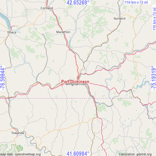
Port Dickinson GPS coordinates[2]
42° 8' 0.276" North, 75° 53' 46.716" West
| Map corner | latitude | longitude |
|---|---|---|
| Upper-left | 42.65269°, | -76.59944° |
| Center: | 42.13341°, | -75.89631° |
| Lower-right: | 41.60984°, | -75.19319° |
| Map W x H: | 116×116 km | = 72.1×72.1mi |
| max Lat: | 71.29058° ⇑23.2% North |
| Port Dickinson: | 42.13341° |
| min Lat: | ⇓76.8% South 19.06759° |
| min Long | Port Dickinson | max Long |
| -171.73463° | -75.89631° | -66.98998° |
| W 84.4%⇐ | ⇒15.6% E |
Elevation
Elevation of Port Dickinson is 263 m = 863 ft, and this is 31.8 m = 104 ft below average elevation for this country.
| Max E: |
3189 m = 10463 ft | 34.8% |
| Avg. | 294.8 m = 967 ft | |
| Port Dickinson | 263 m = 863 ft | |
Min E: |
-60 m = -197 ft | 65.2% |
See also: United States elevation on elevation.city.
Geographical zone
Port Dickinson is located in North temperate zone (between Tropic of Cancer and the Arctic Circle). Distance of this Northern Tropic circle is 2078.9 km =1291.8 mi to South.| Distance of | km | miles | from Port Dickinson |
|---|---|---|---|
| North Pole | 5322.3 | 3307.1 | to North |
| Arctic Circle | 2716.4 | 1687.9 | to North |
| Tropic Cancer | 2078.9 | 1291.8 | to South |
| Equator | 4684.8 | 2911 | to South |


Nearby cities:
15 places around Port Dickinson: (largest is in red/bold)
• Afton
32.2 km =20 mi,  70°
70°
• Apalachin
22.5 km =14 mi,  251°
251°
• Binghamton
4.3 km =2.7 mi,  204°
204°
• Chenango Bridge
4.6 km =2.9 mi,  37°
37°
• Endicott
13.2 km =8.2 mi, 252°
• Endwell
10.5 km =6.5 mi,  257°
257°
• Great Bend
22 km =13.7 mi,  144°
144°
• Greene
24.1 km =15 mi,  25°
25°
• Hallstead
22.9 km =14.2 mi,  146°
146°
• Johnson City
5.5 km =3.4 mi, 249°
• Newark Valley
25.7 km =16 mi,  293°
293°
• Oakland
31.5 km =19.6 mi,  130°
130°
• Owego
30.4 km =18.9 mi, 263°
• Whitney Point
22.5 km =14 mi,  344°
344°
• Windsor
22.1 km =13.7 mi,  106°
106°
Sources, notices
• [Note1] Compared only with cities in United States existing in our database
• [Src1] Map data: © OpenStreetMap contributors (CC-BY-SA)
• [Src2] Other city data from geonames.org with taken over terms of usage.
• [Src3] Geographical zone / Annual Mean Temperature by Robert A. Rohde @ Wikipedia
