Binghamton geodata
Binghamton (New York) is a seat of a second-order administrative division; located in United States in America/New_York (GMT-4) time zone. With population of 46,032 people, there are 1041 cities with bigger population in this country. Compared to other cities in United States, 76.5% of cities are located further ↓South; 84.3% of cities are located further ←West and 66.1% of cities have lower elevation than Binghamton. Note1


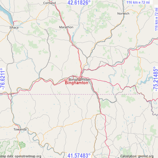
Binghamton GPS coordinates[2]
42° 5' 55.284" North, 75° 55' 4.692" West
| Map corner | latitude | longitude |
|---|---|---|
| Upper-left | 42.61826°, | -76.6211° |
| Center: | 42.09869°, | -75.91797° |
| Lower-right: | 41.57483°, | -75.21485° |
| Map W x H: | 116×116 km | = 72.1×72.1mi |
| max Lat: | 71.29058° ⇑23.5% North |
| Binghamton: | 42.09869° |
| min Lat: | ⇓76.5% South 19.06759° |
| min Long | Binghamton | max Long |
| -171.73463° | -75.91797° | -66.98998° |
| W 84.3%⇐ | ⇒15.7% E |
Elevation
Elevation of Binghamton is 267 m = 876 ft, and this is 27.8 m = 91 ft below average elevation for this country.
| Max E: |
3189 m = 10463 ft | 33.9% |
| Avg. | 294.8 m = 967 ft | |
| Binghamton | 267 m = 876 ft | |
Min E: |
-60 m = -197 ft | 66.1% |
See also: Binghamton elevation on elevation.city.
Geographical zone
Binghamton is located in North temperate zone (between Tropic of Cancer and the Arctic Circle). Distance of this Northern Tropic circle is 2075 km =1289.3 mi to South.| Distance of | km | miles | from Binghamton |
|---|---|---|---|
| North Pole | 5326.1 | 3309.5 | to North |
| Arctic Circle | 2720.2 | 1690.3 | to North |
| Tropic Cancer | 2075 | 1289.3 | to South |
| Equator | 4680.9 | 2908.6 | to South |


Nearby cities:
15 places around Binghamton: (largest is in red/bold)
• Apalachin
19.8 km =12.3 mi,  260°
260°
• Chenango Bridge
8.8 km =5.5 mi,  31°
31°
• Endicott
10.8 km =6.7 mi,  269°
269°
• Endwell
8.6 km =5.3 mi,  280°
280°
• Great Bend
20.2 km =12.6 mi,  134°
134°
• Greene
28.4 km =17.6 mi, 25°
• Hallstead
21 km =13 mi,  136°
136°
• Johnson City
3.9 km =2.4 mi,  299°
299°
• Montrose
29.6 km =18.4 mi,  173°
173°
• New Milford
29.7 km =18.5 mi,  147°
147°
• Newark Valley
25.9 km =16.1 mi, 302°
• Owego
28.4 km =17.6 mi, 271°
• Port Dickinson
4.3 km =2.7 mi,  24°
24°
• Whitney Point
25.9 km =16.1 mi,  350°
350°
• Windsor
23 km =14.3 mi,  96°
96°
Sources, notices
• [Note1] Compared only with cities in United States existing in our database
• [Src1] Map data: © OpenStreetMap contributors (CC-BY-SA)
• [Src2] Other city data from geonames.org with taken over terms of usage.
• [Src3] Geographical zone / Annual Mean Temperature by Robert A. Rohde @ Wikipedia
