Newark Valley geodata
Newark Valley (New York) is a populated place; located in United States in America/New_York (GMT-4) time zone. With population of 957 people, there are 16591 cities with bigger population in this country. Compared to other cities in United States, 77.5% of cities are located further ↓South; 83.5% of cities are located further ←West and 72.2% of cities have lower elevation than Newark Valley. Note1


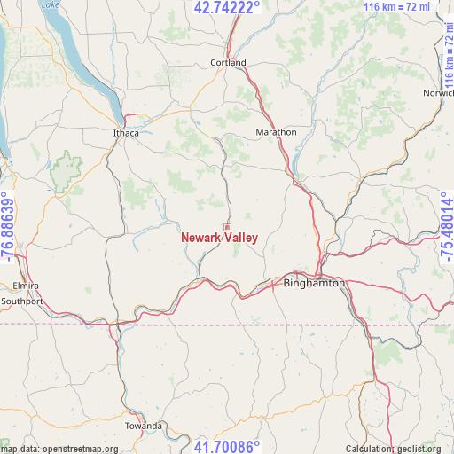
Newark Valley GPS coordinates[2]
42° 13' 25.284" North, 76° 10' 59.736" West
| Map corner | latitude | longitude |
|---|---|---|
| Upper-left | 42.74222°, | -76.88639° |
| Center: | 42.22369°, | -76.18326° |
| Lower-right: | 41.70086°, | -75.48014° |
| Map W x H: | 115.8×115.8 km | = 72×72mi |
| max Lat: | 71.29058° ⇑22.5% North |
| Newark Valley: | 42.22369° |
| min Lat: | ⇓77.5% South 19.06759° |
| min Long | Newark Valley | max Long |
| -171.73463° | -76.18326° | -66.98998° |
| W 83.5%⇐ | ⇒16.5% E |
Elevation
Elevation of Newark Valley is 297 m = 974 ft, and this is 2.2 m = 7 ft above average elevation for this country.
| Max E: |
3189 m = 10463 ft | 27.8% |
| Newark Valley | 297 m 974 ft | |
| Avg. | 294.8 m = 967 ft | |
Min E: |
-60 m = -197 ft | 72.2% |
See also: United States elevation on elevation.city.
Geographical zone
Newark Valley is located in North temperate zone (between Tropic of Cancer and the Arctic Circle). Distance of this Northern Tropic circle is 2088.9 km =1298 mi to South.| Distance of | km | miles | from Newark Valley |
|---|---|---|---|
| North Pole | 5312.2 | 3300.8 | to North |
| Arctic Circle | 2706.3 | 1681.6 | to North |
| Tropic Cancer | 2088.9 | 1298 | to South |
| Equator | 4694.8 | 2917.2 | to South |


Nearby cities:
15 places around Newark Valley: (largest is in red/bold)
• Apalachin
17.3 km =10.7 mi,  172°
172°
• Binghamton
25.9 km =16.1 mi,  122°
122°
• Candor
13.1 km =8.1 mi,  274°
274°
• Chenango Bridge
27.2 km =16.9 mi,  103°
103°
• Dryden
31.2 km =19.4 mi,  342°
342°
• East Ithaca
34.1 km =21.2 mi,  314°
314°
• Endicott
17.8 km =11.1 mi,  141°
141°
• Endwell
18.2 km =11.3 mi,  132°
132°
• Johnson City
22.1 km =13.7 mi, 123°
• Marathon
27.2 km =16.9 mi,  27°
27°
• Owego
14.9 km =9.3 mi,  205°
205°
• Port Dickinson
25.7 km =16 mi,  113°
113°
• Spencer
25.6 km =15.9 mi, 266°
• Van Etten
30.5 km =19 mi,  264°
264°
• Whitney Point
21.2 km =13.2 mi,  56°
56°
Sources, notices
• [Note1] Compared only with cities in United States existing in our database
• [Src1] Map data: © OpenStreetMap contributors (CC-BY-SA)
• [Src2] Other city data from geonames.org with taken over terms of usage.
• [Src3] Geographical zone / Annual Mean Temperature by Robert A. Rohde @ Wikipedia
