Westfield geodata
Westfield (New York) is a populated place; located in United States in America/New_York (GMT-4) time zone. With population of 3,090 people, there are 9478 cities with bigger population in this country. Compared to other cities in United States, 78.3% of cities are located further ↓South; 74.7% of cities are located further ←West and 57.9% of cities have lower elevation than Westfield. Note1


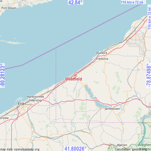
Westfield GPS coordinates[2]
42° 19' 20.208" North, 79° 34' 41.16" West
| Map corner | latitude | longitude |
|---|---|---|
| Upper-left | 42.84°, | -80.28123° |
| Center: | 42.32228°, | -79.5781° |
| Lower-right: | 41.80026°, | -78.87498° |
| Map W x H: | 115.6×115.6 km | = 71.8×71.8mi |
| max Lat: | 71.29058° ⇑21.7% North |
| Westfield: | 42.32228° |
| min Lat: | ⇓78.3% South 19.06759° |
| min Long | Westfield | max Long |
| -171.73463° | -79.5781° | -66.98998° |
| W 74.7%⇐ | ⇒25.3% E |
Elevation
Elevation of Westfield is 230 m = 755 ft, and this is 64.8 m = 213 ft below average elevation for this country.
| Max E: |
3189 m = 10463 ft | 42.1% |
| Avg. | 294.8 m = 967 ft | |
| Westfield | 230 m = 755 ft | |
Min E: |
-60 m = -197 ft | 57.9% |
See also: United States elevation on elevation.city.
Geographical zone
Westfield is located in North temperate zone (between Tropic of Cancer and the Arctic Circle). Distance of this Northern Tropic circle is 2099.9 km =1304.8 mi to South.| Distance of | km | miles | from Westfield |
|---|---|---|---|
| North Pole | 5301.3 | 3294.1 | to North |
| Arctic Circle | 2695.4 | 1674.8 | to North |
| Tropic Cancer | 2099.9 | 1304.8 | to South |
| Equator | 4705.8 | 2924 | to South |


Nearby cities:
15 places around Westfield: (largest is in red/bold)
• Brocton
13.5 km =8.4 mi,  56°
56°
• Cassadaga
22.2 km =13.8 mi,  83°
83°
• Celoron
33.9 km =21.1 mi,  134°
134°
• Clymer
33.8 km =21 mi,  187°
187°
• Dunkirk
26.6 km =16.5 mi,  48°
48°
• Forestville
36.7 km =22.8 mi, 63°
• Fredonia
24.1 km =15 mi, 57°
• Jamestown West
35.7 km =22.2 mi,  136°
136°
• Lakewood
31.5 km =19.6 mi, 140°
• Mayville
9.7 km =6 mi, 141°
• North East
24.2 km =15 mi,  240°
240°
• Portland
11.1 km =6.9 mi, 54°
• Ripley
12.5 km =7.8 mi, 240°
• Sherman
18.2 km =11.3 mi,  184°
184°
• Sinclairville
27.1 km =16.8 mi,  103°
103°
Sources, notices
• [Note1] Compared only with cities in United States existing in our database
• [Src1] Map data: © OpenStreetMap contributors (CC-BY-SA)
• [Src2] Other city data from geonames.org with taken over terms of usage.
• [Src3] Geographical zone / Annual Mean Temperature by Robert A. Rohde @ Wikipedia
