Kenton geodata
Kenton (Ohio) is a seat of a second-order administrative division; located in United States in America/New_York (GMT-4) time zone. With population of 8,211 people, there are 5188 cities with bigger population in this country. Compared to other cities in United States, 60.8% of cities are located further ↓South; 60.3% of cities are located further ←West and 72.2% of cities have lower elevation than Kenton. Note1


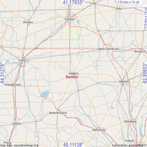
Kenton GPS coordinates[2]
40° 38' 49.2" North, 83° 36' 34.74" West
| Map corner | latitude | longitude |
|---|---|---|
| Upper-left | 41.17835°, | -84.31278° |
| Center: | 40.647°, | -83.60965° |
| Lower-right: | 40.11138°, | -82.90653° |
| Map W x H: | 118.6×118.6 km | = 73.7×73.7mi |
| max Lat: | 71.29058° ⇑39.2% North |
| Kenton: | 40.647° |
| min Lat: | ⇓60.8% South 19.06759° |
| min Long | Kenton | max Long |
| -171.73463° | -83.60965° | -66.98998° |
| W 60.3%⇐ | ⇒39.7% E |
Elevation
Elevation of Kenton is 297 m = 974 ft, and this is 2.2 m = 7 ft above average elevation for this country.
| Max E: |
3189 m = 10463 ft | 27.8% |
| Kenton | 297 m 974 ft | |
| Avg. | 294.8 m = 967 ft | |
Min E: |
-60 m = -197 ft | 72.2% |
See also: United States elevation on elevation.city.
Geographical zone
Kenton is located in North temperate zone (between Tropic of Cancer and the Arctic Circle). Distance of this Northern Tropic circle is 1913.6 km =1189.1 mi to South.| Distance of | km | miles | from Kenton |
|---|---|---|---|
| North Pole | 5487.5 | 3409.8 | to North |
| Arctic Circle | 2881.7 | 1790.6 | to North |
| Tropic Cancer | 1913.6 | 1189.1 | to South |
| Equator | 4519.5 | 2808.3 | to South |


Nearby cities:
15 places around Kenton: (largest is in red/bold)
• Ada
22.5 km =14 mi,  307°
307°
• Alger
20.8 km =12.9 mi,  288°
288°
• Arlington
27.6 km =17.1 mi,  352°
352°
• Belle Center
19.5 km =12.1 mi,  216°
216°
• Chippewa Park
27.8 km =17.3 mi,  238°
238°
• Dunkirk
16.1 km =10 mi, 349°
• Forest
19.1 km =11.9 mi,  25°
25°
• La Rue
20.5 km =12.7 mi,  112°
112°
• Lakeview
32 km =19.9 mi, 235°
• Mount Victory
14.6 km =9.1 mi,  148°
148°
• Northwood
22 km =13.7 mi,  208°
208°
• Rushsylvania
21.3 km =13.2 mi,  193°
193°
• Russells Point
30.9 km =19.2 mi,  230°
230°
• Waynesfield
31.3 km =19.4 mi,  260°
260°
• West Mansfield
27.8 km =17.3 mi,  168°
168°
Sources, notices
• [Note1] Compared only with cities in United States existing in our database
• [Src1] Map data: © OpenStreetMap contributors (CC-BY-SA)
• [Src2] Other city data from geonames.org with taken over terms of usage.
• [Src3] Geographical zone / Annual Mean Temperature by Robert A. Rohde @ Wikipedia
