West Mansfield geodata
West Mansfield (Ohio) is a populated place; located in United States in America/New_York (GMT-4) time zone. With population of 667 people, there are 19002 cities with bigger population in this country. Compared to other cities in United States, 57.9% of cities are located further ↓South; 60.5% of cities are located further ←West and 77.5% of cities have lower elevation than West Mansfield. Note1


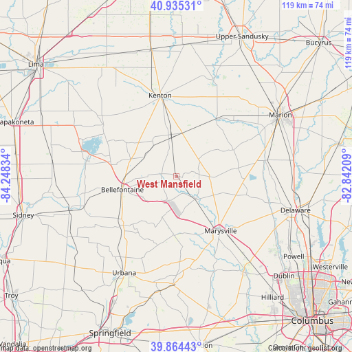
West Mansfield GPS coordinates[2]
40° 24' 7.2" North, 83° 32' 42.756" West
| Map corner | latitude | longitude |
|---|---|---|
| Upper-left | 40.93531°, | -84.24834° |
| Center: | 40.402°, | -83.54521° |
| Lower-right: | 39.86443°, | -82.84209° |
| Map W x H: | 119.1×119.1 km | = 74×74mi |
| max Lat: | 71.29058° ⇑42.1% North |
| West Mansfield: | 40.402° |
| min Lat: | ⇓57.9% South 19.06759° |
| min Long | West Mansfield | max Long |
| -171.73463° | -83.54521° | -66.98998° |
| W 60.5%⇐ | ⇒39.5% E |
Elevation
Elevation of West Mansfield is 332 m = 1089 ft, and this is 37.2 m = 122 ft above average elevation for this country.
| Max E: |
3189 m = 10463 ft | 22.5% |
| West Mansfield | 332 m 1089 ft | |
| Avg. | 294.8 m = 967 ft | |
Min E: |
-60 m = -197 ft | 77.5% |
See also: United States elevation on elevation.city.
Geographical zone
West Mansfield is located in North temperate zone (between Tropic of Cancer and the Arctic Circle). Distance of this Northern Tropic circle is 1886.4 km =1172.2 mi to South.| Distance of | km | miles | from West Mansfield |
|---|---|---|---|
| North Pole | 5514.8 | 3426.7 | to North |
| Arctic Circle | 2908.9 | 1807.5 | to North |
| Tropic Cancer | 1886.4 | 1172.2 | to South |
| Equator | 4492.3 | 2791.4 | to South |


Nearby cities:
15 places around West Mansfield: (largest is in red/bold)
• Belle Center
20.7 km =12.9 mi,  304°
304°
• Bellefontaine
18.7 km =11.6 mi,  255°
255°
• Chippewa Park
31.7 km =19.7 mi,  293°
293°
• Kenton
27.8 km =17.3 mi,  348°
348°
• La Rue
23.7 km =14.7 mi,  34°
34°
• Marysville
23.8 km =14.8 mi,  140°
140°
• Milford Center
26.5 km =16.5 mi,  159°
159°
• Mount Victory
14.9 km =9.3 mi,  8°
8°
• North Lewisburg
19.9 km =12.4 mi,  182°
182°
• Northwood
17.7 km =11 mi, 296°
• Prospect
30.7 km =19.1 mi,  79°
79°
• Richwood
21.2 km =13.2 mi, 82°
• Rushsylvania
12.5 km =7.8 mi, 302°
• Russells Point
30.4 km =18.9 mi,  284°
284°
• West Liberty
24.4 km =15.2 mi,  226°
226°
Sources, notices
• [Note1] Compared only with cities in United States existing in our database
• [Src1] Map data: © OpenStreetMap contributors (CC-BY-SA)
• [Src2] Other city data from geonames.org with taken over terms of usage.
• [Src3] Geographical zone / Annual Mean Temperature by Robert A. Rohde @ Wikipedia
