Convoy geodata
Convoy (Ohio) is a populated place; located in United States in America/New_York (GMT-4) time zone. With population of 1,068 people, there are 15859 cities with bigger population in this country. Compared to other cities in United States, 64.9% of cities are located further ↓South; 56.6% of cities are located further ←West and 59.9% of cities have lower elevation than Convoy. Note1


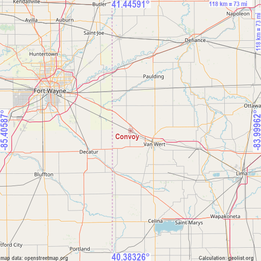
Convoy GPS coordinates[2]
40° 55' 0.192" North, 84° 42' 9.864" West
| Map corner | latitude | longitude |
|---|---|---|
| Upper-left | 41.44591°, | -85.40587° |
| Center: | 40.91672°, | -84.70274° |
| Lower-right: | 40.38326°, | -83.99962° |
| Map W x H: | 118.2×118.2 km | = 73.4×73.4mi |
| max Lat: | 71.29058° ⇑35.1% North |
| Convoy: | 40.91672° |
| min Lat: | ⇓64.9% South 19.06759° |
| min Long | Convoy | max Long |
| -171.73463° | -84.70274° | -66.98998° |
| W 56.6%⇐ | ⇒43.4% E |
Elevation
Elevation of Convoy is 239 m = 784 ft, and this is 55.8 m = 183 ft below average elevation for this country.
| Max E: |
3189 m = 10463 ft | 40.1% |
| Avg. | 294.8 m = 967 ft | |
| Convoy | 239 m = 784 ft | |
Min E: |
-60 m = -197 ft | 59.9% |
See also: United States elevation on elevation.city.
Geographical zone
Convoy is located in North temperate zone (between Tropic of Cancer and the Arctic Circle). Distance of this Northern Tropic circle is 1943.6 km =1207.7 mi to South.| Distance of | km | miles | from Convoy |
|---|---|---|---|
| North Pole | 5457.5 | 3391.1 | to North |
| Arctic Circle | 2851.7 | 1772 | to North |
| Tropic Cancer | 1943.6 | 1207.7 | to South |
| Equator | 4549.5 | 2826.9 | to South |


Nearby cities:
15 places around Convoy: (largest is in red/bold)
• Antwerp
29.6 km =18.4 mi,  353°
353°
• Decatur
21.3 km =13.2 mi,  243°
243°
• Hoagland
24.5 km =15.2 mi,  278°
278°
• Mendon
31.2 km =19.4 mi,  150°
150°
• Middle Point
22.5 km =14 mi,  107°
107°
• Monroe
27.4 km =17 mi,  225°
225°
• Monroeville
15.3 km =9.5 mi,  294°
294°
• New Haven
31.3 km =19.4 mi,  303°
303°
• Ohio City
17.7 km =11 mi,  155°
155°
• Ottoville
30.6 km =19 mi,  86°
86°
• Paulding
26.7 km =16.6 mi,  22°
22°
• Payne
18 km =11.2 mi, 353°
• Rockford
25.9 km =16.1 mi,  169°
169°
• Van Wert
11.3 km =7 mi,  117°
117°
• Woodburn
26.4 km =16.4 mi,  331°
331°
Sources, notices
• [Note1] Compared only with cities in United States existing in our database
• [Src1] Map data: © OpenStreetMap contributors (CC-BY-SA)
• [Src2] Other city data from geonames.org with taken over terms of usage.
• [Src3] Geographical zone / Annual Mean Temperature by Robert A. Rohde @ Wikipedia
