Decatur geodata
Decatur (Indiana) is a seat of a second-order administrative division; located in United States in America/Indiana/Indianapolis (GMT-4) time zone. With population of 9,465 people, there are 4636 cities with bigger population in this country. Compared to other cities in United States, 63.7% of cities are located further ↓South; 56% of cities are located further ←West and 61.2% of cities have lower elevation than Decatur. Note1


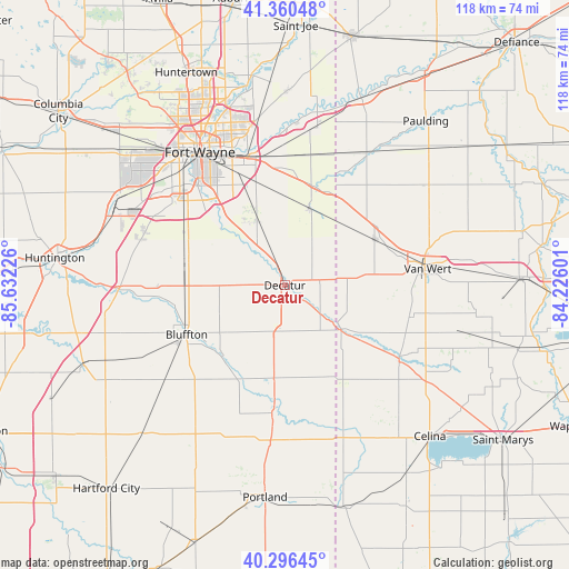
Decatur GPS coordinates[2]
40° 49' 50.16" North, 84° 55' 44.868" West
| Map corner | latitude | longitude |
|---|---|---|
| Upper-left | 41.36048°, | -85.63226° |
| Center: | 40.8306°, | -84.92913° |
| Lower-right: | 40.29645°, | -84.22601° |
| Map W x H: | 118.3×118.3 km | = 73.5×73.5mi |
| max Lat: | 71.29058° ⇑36.3% North |
| Decatur: | 40.8306° |
| min Lat: | ⇓63.7% South 19.06759° |
| min Long | Decatur | max Long |
| -171.73463° | -84.92913° | -66.98998° |
| W 56%⇐ | ⇒44% E |
Elevation
Elevation of Decatur is 245 m = 804 ft, and this is 49.8 m = 163 ft below average elevation for this country.
| Max E: |
3189 m = 10463 ft | 38.8% |
| Avg. | 294.8 m = 967 ft | |
| Decatur | 245 m = 804 ft | |
Min E: |
-60 m = -197 ft | 61.2% |
See also: United States elevation on elevation.city.
Geographical zone
Decatur is located in North temperate zone (between Tropic of Cancer and the Arctic Circle). Distance of this Northern Tropic circle is 1934 km =1201.7 mi to South.| Distance of | km | miles | from Decatur |
|---|---|---|---|
| North Pole | 5467.1 | 3397.1 | to North |
| Arctic Circle | 2861.2 | 1777.9 | to North |
| Tropic Cancer | 1934 | 1201.7 | to South |
| Equator | 4539.9 | 2821 | to South |


Nearby cities:
15 places around Decatur: (largest is in red/bold)
• Berne
19.3 km =12 mi,  185°
185°
• Bluffton
22.8 km =14.2 mi,  243°
243°
• Convoy
21.3 km =13.2 mi,  63°
63°
• Geneva
26.6 km =16.5 mi, 185°
• Hoagland
14.1 km =8.8 mi,  338°
338°
• Monroe
9.5 km =5.9 mi,  183°
183°
• Monroeville
16.8 km =10.4 mi,  17°
17°
• New Haven
27.6 km =17.1 mi, 344°
• Ohio City
27.2 km =16.9 mi,  103°
103°
• Ossian
20.7 km =12.9 mi,  285°
285°
• Payne
32.3 km =20.1 mi,  31°
31°
• Rockford
28.6 km =17.8 mi,  123°
123°
• Van Wert
29.3 km =18.2 mi,  81°
81°
• Woodburn
33.4 km =20.8 mi,  10°
10°
• Zanesville
31.1 km =19.3 mi, 288°
Sources, notices
• [Note1] Compared only with cities in United States existing in our database
• [Src1] Map data: © OpenStreetMap contributors (CC-BY-SA)
• [Src2] Other city data from geonames.org with taken over terms of usage.
• [Src3] Geographical zone / Annual Mean Temperature by Robert A. Rohde @ Wikipedia
