Van Wert geodata
Van Wert (Ohio) is a seat of a second-order administrative division; located in United States in America/New_York (GMT-4) time zone. With population of 10,798 people, there are 4233 cities with bigger population in this country. Compared to other cities in United States, 64.3% of cities are located further ↓South; 57% of cities are located further ←West and 59.4% of cities have lower elevation than Van Wert. Note1


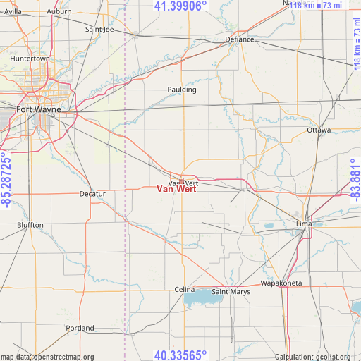
Van Wert GPS coordinates[2]
40° 52' 10.164" North, 84° 35' 2.832" West
| Map corner | latitude | longitude |
|---|---|---|
| Upper-left | 41.39906°, | -85.28725° |
| Center: | 40.86949°, | -84.58412° |
| Lower-right: | 40.33565°, | -83.881° |
| Map W x H: | 118.2×118.2 km | = 73.4×73.4mi |
| max Lat: | 71.29058° ⇑35.7% North |
| Van Wert: | 40.86949° |
| min Lat: | ⇓64.3% South 19.06759° |
| min Long | Van Wert | max Long |
| -171.73463° | -84.58412° | -66.98998° |
| W 57%⇐ | ⇒43% E |
Elevation
Elevation of Van Wert is 237 m = 778 ft, and this is 57.8 m = 190 ft below average elevation for this country.
| Max E: |
3189 m = 10463 ft | 40.6% |
| Avg. | 294.8 m = 967 ft | |
| Van Wert | 237 m = 778 ft | |
Min E: |
-60 m = -197 ft | 59.4% |
See also: United States elevation on elevation.city.
Geographical zone
Van Wert is located in North temperate zone (between Tropic of Cancer and the Arctic Circle). Distance of this Northern Tropic circle is 1938.3 km =1204.4 mi to South.| Distance of | km | miles | from Van Wert |
|---|---|---|---|
| North Pole | 5462.8 | 3394.4 | to North |
| Arctic Circle | 2856.9 | 1775.2 | to North |
| Tropic Cancer | 1938.3 | 1204.4 | to South |
| Equator | 4544.3 | 2823.7 | to South |


Nearby cities:
15 places around Van Wert: (largest is in red/bold)
• Convoy
11.3 km =7 mi,  297°
297°
• Decatur
29.3 km =18.2 mi,  261°
261°
• Delphos
20.6 km =12.8 mi,  98°
98°
• Elida
33.2 km =20.6 mi,  105°
105°
• Mendon
22.5 km =14 mi,  165°
165°
• Middle Point
11.6 km =7.2 mi, 97°
• Monroe
32.8 km =20.4 mi,  245°
245°
• Monroeville
26.6 km =16.5 mi, 296°
• Oakwood
30.4 km =18.9 mi,  34°
34°
• Ohio City
11.2 km =7 mi,  193°
193°
• Ottoville
21.8 km =13.5 mi,  71°
71°
• Paulding
29.9 km =18.6 mi,  0°
0°
• Payne
26.1 km =16.2 mi,  332°
332°
• Rockford
20.9 km =13 mi, 194°
• Spencerville
26.4 km =16.4 mi,  132°
132°
Sources, notices
• [Note1] Compared only with cities in United States existing in our database
• [Src1] Map data: © OpenStreetMap contributors (CC-BY-SA)
• [Src2] Other city data from geonames.org with taken over terms of usage.
• [Src3] Geographical zone / Annual Mean Temperature by Robert A. Rohde @ Wikipedia
