Fostoria geodata
Fostoria (Ohio) is a populated place; located in United States in America/New_York (GMT-4) time zone. With population of 13,167 people, there are 3631 cities with bigger population in this country. Compared to other cities in United States, 67.4% of cities are located further ↓South; 60.8% of cities are located further ←West and 59.9% of cities have lower elevation than Fostoria. Note1


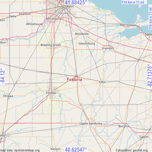
Fostoria GPS coordinates[2]
41° 9' 25.2" North, 83° 25' 0.732" West
| Map corner | latitude | longitude |
|---|---|---|
| Upper-left | 41.68425°, | -84.12° |
| Center: | 41.157°, | -83.41687° |
| Lower-right: | 40.62547°, | -82.71375° |
| Map W x H: | 117.7×117.7 km | = 73.1×73.1mi |
| max Lat: | 71.29058° ⇑32.6% North |
| Fostoria: | 41.157° |
| min Lat: | ⇓67.4% South 19.06759° |
| min Long | Fostoria | max Long |
| -171.73463° | -83.41687° | -66.98998° |
| W 60.8%⇐ | ⇒39.2% E |
Elevation
Elevation of Fostoria is 239 m = 784 ft, and this is 55.8 m = 183 ft below average elevation for this country.
| Max E: |
3189 m = 10463 ft | 40.1% |
| Avg. | 294.8 m = 967 ft | |
| Fostoria | 239 m = 784 ft | |
Min E: |
-60 m = -197 ft | 59.9% |
See also: United States elevation on elevation.city.
Geographical zone
Fostoria is located in North temperate zone (between Tropic of Cancer and the Arctic Circle). Distance of this Northern Tropic circle is 1970.3 km =1224.3 mi to South.| Distance of | km | miles | from Fostoria |
|---|---|---|---|
| North Pole | 5430.8 | 3374.5 | to North |
| Arctic Circle | 2824.9 | 1755.3 | to North |
| Tropic Cancer | 1970.3 | 1224.3 | to South |
| Equator | 4576.2 | 2843.5 | to South |


Nearby cities:
15 places around Fostoria: (largest is in red/bold)
• Arcadia
10 km =6.2 mi,  237°
237°
• Ballville
30.5 km =19 mi,  51°
51°
• Bettsville
18.1 km =11.2 mi,  56°
56°
• Bloomdale
11.8 km =7.3 mi,  278°
278°
• Bradner
18.7 km =11.6 mi,  354°
354°
• Carey
22.9 km =14.2 mi,  172°
172°
• Cygnet
21.1 km =13.1 mi,  295°
295°
• Findlay
23.2 km =14.4 mi, 237°
• Gibsonburg
26.5 km =16.5 mi,  17°
17°
• North Baltimore
22.1 km =13.7 mi, 277°
• Pemberville
28.5 km =17.7 mi, 352°
• Risingsun
12.5 km =7.8 mi,  356°
356°
• Stony Prairie
30.8 km =19.1 mi, 45°
• Tiffin
20.6 km =12.8 mi,  103°
103°
• Wayne
16.7 km =10.4 mi,  343°
343°
Sources, notices
• [Note1] Compared only with cities in United States existing in our database
• [Src1] Map data: © OpenStreetMap contributors (CC-BY-SA)
• [Src2] Other city data from geonames.org with taken over terms of usage.
• [Src3] Geographical zone / Annual Mean Temperature by Robert A. Rohde @ Wikipedia
