Eaton Estates geodata
Eaton Estates (Ohio) is a populated place; located in United States in America/New_York (GMT-4) time zone. With population of 1,222 people, there are 15001 cities with bigger population in this country. Compared to other cities in United States, 68.9% of cities are located further ↓South; 65.5% of cities are located further ←West and 61.2% of cities have lower elevation than Eaton Estates. Note1


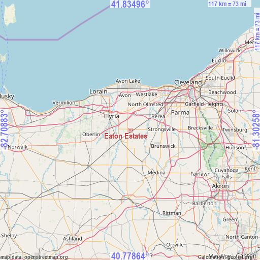
Eaton Estates GPS coordinates[2]
41° 18' 32.184" North, 82° 0' 20.52" West
| Map corner | latitude | longitude |
|---|---|---|
| Upper-left | 41.83496°, | -82.70883° |
| Center: | 41.30894°, | -82.0057° |
| Lower-right: | 40.77864°, | -81.30258° |
| Map W x H: | 117.5×117.5 km | = 73×73mi |
| max Lat: | 71.29058° ⇑31.1% North |
| Eaton Estates: | 41.30894° |
| min Lat: | ⇓68.9% South 19.06759° |
| min Long | Eaton Estates | max Long |
| -171.73463° | -82.0057° | -66.98998° |
| W 65.5%⇐ | ⇒34.5% E |
Elevation
Elevation of Eaton Estates is 245 m = 804 ft, and this is 49.8 m = 163 ft below average elevation for this country.
| Max E: |
3189 m = 10463 ft | 38.8% |
| Avg. | 294.8 m = 967 ft | |
| Eaton Estates | 245 m = 804 ft | |
Min E: |
-60 m = -197 ft | 61.2% |
See also: United States elevation on elevation.city.
Geographical zone
Eaton Estates is located in North temperate zone (between Tropic of Cancer and the Arctic Circle). Distance of this Northern Tropic circle is 1987.2 km =1234.8 mi to South.| Distance of | km | miles | from Eaton Estates |
|---|---|---|---|
| North Pole | 5413.9 | 3364 | to North |
| Arctic Circle | 2808.1 | 1744.9 | to North |
| Tropic Cancer | 1987.2 | 1234.8 | to South |
| Equator | 4593.1 | 2854 | to South |


Nearby cities:
15 places around Eaton Estates: (largest is in red/bold)
• Avon
16.1 km =10 mi,  351°
351°
• Avon Center
16.8 km =10.4 mi,  356°
356°
• Berea
14.2 km =8.8 mi,  63°
63°
• Brunswick
15.8 km =9.8 mi,  119°
119°
• Elyria
10.8 km =6.7 mi,  307°
307°
• Grafton
5.7 km =3.5 mi,  225°
225°
• Lagrange
12.4 km =7.7 mi, 230°
• Middleburg Heights
17.1 km =10.6 mi,  70°
70°
• North Olmsted
13.7 km =8.5 mi,  30°
30°
• North Ridgeville
9 km =5.6 mi, 352°
• Oberlin
17.8 km =11.1 mi,  264°
264°
• Olmsted Falls
11 km =6.8 mi,  47°
47°
• Sheffield
14.6 km =9.1 mi,  328°
328°
• Strongsville
14.2 km =8.8 mi,  87°
87°
• Westlake
17.8 km =11.1 mi,  24°
24°
Sources, notices
• [Note1] Compared only with cities in United States existing in our database
• [Src1] Map data: © OpenStreetMap contributors (CC-BY-SA)
• [Src2] Other city data from geonames.org with taken over terms of usage.
• [Src3] Geographical zone / Annual Mean Temperature by Robert A. Rohde @ Wikipedia
