North Olmsted geodata
North Olmsted (Ohio) is a populated place; located in United States in America/New_York (GMT-4) time zone. With population of 32,004 people, there are 1562 cities with bigger population in this country. Compared to other cities in United States, 69.9% of cities are located further ↓South; 65.8% of cities are located further ←West and 58.2% of cities have lower elevation than North Olmsted. Note1


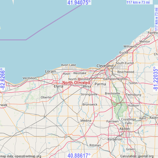
North Olmsted GPS coordinates[2]
41° 24' 56.16" North, 81° 55' 24.492" West
| Map corner | latitude | longitude |
|---|---|---|
| Upper-left | 41.94075°, | -82.6266° |
| Center: | 41.4156°, | -81.92347° |
| Lower-right: | 40.88617°, | -81.22035° |
| Map W x H: | 117.3×117.3 km | = 72.9×72.9mi |
| max Lat: | 71.29058° ⇑30.1% North |
| North Olmsted: | 41.4156° |
| min Lat: | ⇓69.9% South 19.06759° |
| min Long | North Olmsted | max Long |
| -171.73463° | -81.92347° | -66.98998° |
| W 65.8%⇐ | ⇒34.2% E |
Elevation
Elevation of North Olmsted is 231 m = 758 ft, and this is 63.8 m = 209 ft below average elevation for this country.
| Max E: |
3189 m = 10463 ft | 41.8% |
| Avg. | 294.8 m = 967 ft | |
| North Olmsted | 231 m = 758 ft | |
Min E: |
-60 m = -197 ft | 58.2% |
See also: United States elevation on elevation.city.
Geographical zone
North Olmsted is located in North temperate zone (between Tropic of Cancer and the Arctic Circle). Distance of this Northern Tropic circle is 1999.1 km =1242.2 mi to South.| Distance of | km | miles | from North Olmsted |
|---|---|---|---|
| North Pole | 5402.1 | 3356.7 | to North |
| Arctic Circle | 2796.2 | 1737.5 | to North |
| Tropic Cancer | 1999.1 | 1242.2 | to South |
| Equator | 4605 | 2861.4 | to South |


Nearby cities:
15 places around North Olmsted: (largest is in red/bold)
• Avon
10.2 km =6.3 mi,  293°
293°
• Avon Center
9.4 km =5.8 mi,  301°
301°
• Avon Lake
13.3 km =8.3 mi,  318°
318°
• Bay Village
7.7 km =4.8 mi,  0°
0°
• Berea
8 km =5 mi,  133°
133°
• Brook Park
10.1 km =6.3 mi,  100°
100°
• Eaton Estates
13.7 km =8.5 mi,  210°
210°
• Fairview Park
5.7 km =3.5 mi,  59°
59°
• Lakewood
12.8 km =8 mi,  54°
54°
• Middleburg Heights
11 km =6.8 mi,  123°
123°
• North Ridgeville
8.5 km =5.3 mi,  249°
249°
• Olmsted Falls
4.7 km =2.9 mi,  164°
164°
• Rocky River
9.7 km =6 mi, 46°
• Strongsville
13.4 km =8.3 mi,  146°
146°
• Westlake
4.4 km =2.7 mi,  5°
5°
Sources, notices
• [Note1] Compared only with cities in United States existing in our database
• [Src1] Map data: © OpenStreetMap contributors (CC-BY-SA)
• [Src2] Other city data from geonames.org with taken over terms of usage.
• [Src3] Geographical zone / Annual Mean Temperature by Robert A. Rohde @ Wikipedia
