Elyria geodata
Elyria (Ohio) is a seat of a second-order administrative division; located in United States in America/New_York (GMT-4) time zone. With population of 53,775 people, there are 867 cities with bigger population in this country. Compared to other cities in United States, 69.5% of cities are located further ↓South; 65.2% of cities are located further ←West and 55.8% of cities have lower elevation than Elyria. Note1


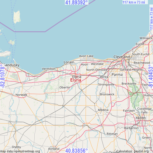
Elyria GPS coordinates[2]
41° 22' 6.168" North, 82° 6' 27.54" West
| Map corner | latitude | longitude |
|---|---|---|
| Upper-left | 41.89392°, | -82.81078° |
| Center: | 41.36838°, | -82.10765° |
| Lower-right: | 40.83856°, | -81.40453° |
| Map W x H: | 117.3×117.3 km | = 72.9×72.9mi |
| max Lat: | 71.29058° ⇑30.5% North |
| Elyria: | 41.36838° |
| min Lat: | ⇓69.5% South 19.06759° |
| min Long | Elyria | max Long |
| -171.73463° | -82.10765° | -66.98998° |
| W 65.2%⇐ | ⇒34.8% E |
Elevation
Elevation of Elyria is 222 m = 728 ft, and this is 72.8 m = 239 ft below average elevation for this country.
| Max E: |
3189 m = 10463 ft | 44.2% |
| Avg. | 294.8 m = 967 ft | |
| Elyria | 222 m = 728 ft | |
Min E: |
-60 m = -197 ft | 55.8% |
See also: Elyria elevation on elevation.city.
Geographical zone
Elyria is located in North temperate zone (between Tropic of Cancer and the Arctic Circle). Distance of this Northern Tropic circle is 1993.8 km =1238.9 mi to South.| Distance of | km | miles | from Elyria |
|---|---|---|---|
| North Pole | 5407.3 | 3359.9 | to North |
| Arctic Circle | 2801.4 | 1740.7 | to North |
| Tropic Cancer | 1993.8 | 1238.9 | to South |
| Equator | 4599.7 | 2858.1 | to South |


Nearby cities:
15 places around Elyria: (largest is in red/bold)
• Amherst
10.1 km =6.3 mi,  288°
288°
• Avon
11.1 km =6.9 mi,  33°
33°
• Avon Center
12.5 km =7.8 mi,  35°
35°
• Avon Lake
16.6 km =10.3 mi,  23°
23°
• Eaton Estates
10.8 km =6.7 mi,  127°
127°
• Grafton
11.5 km =7.1 mi,  157°
157°
• Lagrange
14.6 km =9.1 mi,  184°
184°
• Lorain
11.3 km =7 mi,  326°
326°
• North Olmsted
16.2 km =10.1 mi,  71°
71°
• North Ridgeville
7.8 km =4.8 mi, 72°
• Oberlin
12.3 km =7.6 mi,  227°
227°
• Sheffield
5.9 km =3.7 mi,  9°
9°
• Sheffield
10.5 km =6.5 mi,  4°
4°
• Sheffield Lake
13.3 km =8.3 mi, 2°
• South Amherst
12.3 km =7.6 mi,  263°
263°
Sources, notices
• [Note1] Compared only with cities in United States existing in our database
• [Src1] Map data: © OpenStreetMap contributors (CC-BY-SA)
• [Src2] Other city data from geonames.org with taken over terms of usage.
• [Src3] Geographical zone / Annual Mean Temperature by Robert A. Rohde @ Wikipedia
