Carey geodata
Carey (Ohio) is a populated place; located in United States in America/New_York (GMT-4) time zone. With population of 3,586 people, there are 8739 cities with bigger population in this country. Compared to other cities in United States, 65.4% of cities are located further ↓South; 61% of cities are located further ←West and 62.6% of cities have lower elevation than Carey. Note1


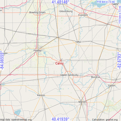
Carey GPS coordinates[2]
40° 57' 9.216" North, 83° 22' 56.712" West
| Map corner | latitude | longitude |
|---|---|---|
| Upper-left | 41.48146°, | -84.08555° |
| Center: | 40.95256°, | -83.38242° |
| Lower-right: | 40.41939°, | -82.6793° |
| Map W x H: | 118.1×118.1 km | = 73.4×73.4mi |
| max Lat: | 71.29058° ⇑34.6% North |
| Carey: | 40.95256° |
| min Lat: | ⇓65.4% South 19.06759° |
| min Long | Carey | max Long |
| -171.73463° | -83.38242° | -66.98998° |
| W 61%⇐ | ⇒39% E |
Elevation
Elevation of Carey is 251 m = 823 ft, and this is 43.8 m = 144 ft below average elevation for this country.
| Max E: |
3189 m = 10463 ft | 37.4% |
| Avg. | 294.8 m = 967 ft | |
| Carey | 251 m = 823 ft | |
Min E: |
-60 m = -197 ft | 62.6% |
See also: United States elevation on elevation.city.
Geographical zone
Carey is located in North temperate zone (between Tropic of Cancer and the Arctic Circle). Distance of this Northern Tropic circle is 1947.6 km =1210.2 mi to South.| Distance of | km | miles | from Carey |
|---|---|---|---|
| North Pole | 5453.6 | 3388.7 | to North |
| Arctic Circle | 2847.7 | 1769.5 | to North |
| Tropic Cancer | 1947.6 | 1210.2 | to South |
| Equator | 4553.5 | 2829.4 | to South |


Nearby cities:
15 places around Carey: (largest is in red/bold)
• Arcadia
20.7 km =12.9 mi,  326°
326°
• Arlington
23.4 km =14.5 mi,  253°
253°
• Bettsville
34.9 km =21.7 mi,  20°
20°
• Bloomdale
28.5 km =17.7 mi, 329°
• Bloomville
32.8 km =20.4 mi,  70°
70°
• Dunkirk
28.5 km =17.7 mi,  230°
230°
• Findlay
24.7 km =15.3 mi,  294°
294°
• Forest
19.9 km =12.4 mi,  212°
212°
• Fostoria
22.9 km =14.2 mi,  352°
352°
• Nevada
25.9 km =16.1 mi,  124°
124°
• Rawson
33.7 km =20.9 mi,  271°
271°
• Risingsun
35.4 km =22 mi, 354°
• Sycamore
17.8 km =11.1 mi,  90°
90°
• Tiffin
24.9 km =15.5 mi,  43°
43°
• Upper Sandusky
16.3 km =10.1 mi,  148°
148°
Sources, notices
• [Note1] Compared only with cities in United States existing in our database
• [Src1] Map data: © OpenStreetMap contributors (CC-BY-SA)
• [Src2] Other city data from geonames.org with taken over terms of usage.
• [Src3] Geographical zone / Annual Mean Temperature by Robert A. Rohde @ Wikipedia
