Clark-Fulton geodata
Clark-Fulton (Ohio) is a populated place; located in United States in America/New_York (GMT-4) time zone. With population of 18,185 people, there are 2758 cities with bigger population in this country. Compared to other cities in United States, 70.5% of cities are located further ↓South; 66.7% of cities are located further ←West and 53% of cities have lower elevation than Clark-Fulton. Note1


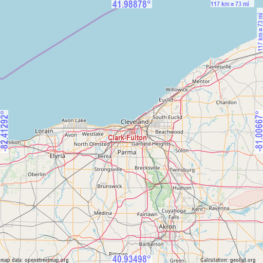
Clark-Fulton GPS coordinates[2]
41° 27' 50.472" North, 81° 42' 35.244" West
| Map corner | latitude | longitude |
|---|---|---|
| Upper-left | 41.98878°, | -82.41292° |
| Center: | 41.46402°, | -81.70979° |
| Lower-right: | 40.93498°, | -81.00667° |
| Map W x H: | 117.2×117.2 km | = 72.8×72.8mi |
| max Lat: | 71.29058° ⇑29.5% North |
| Clark-Fulton: | 41.46402° |
| min Lat: | ⇓70.5% South 19.06759° |
| min Long | Clark-Fulton | max Long |
| -171.73463° | -81.70979° | -66.98998° |
| W 66.7%⇐ | ⇒33.3% E |
Elevation
Elevation of Clark-Fulton is 210 m = 689 ft, and this is 84.8 m = 278 ft below average elevation for this country.
| Max E: |
3189 m = 10463 ft | 47% |
| Avg. | 294.8 m = 967 ft | |
| Clark-Fulton | 210 m = 689 ft | |
Min E: |
-60 m = -197 ft | 53% |
See also: United States elevation on elevation.city.
Geographical zone
Clark-Fulton is located in North temperate zone (between Tropic of Cancer and the Arctic Circle). Distance of this Northern Tropic circle is 2004.4 km =1245.5 mi to South.| Distance of | km | miles | from Clark-Fulton |
|---|---|---|---|
| North Pole | 5396.7 | 3353.4 | to North |
| Arctic Circle | 2790.8 | 1734.1 | to North |
| Tropic Cancer | 2004.4 | 1245.5 | to South |
| Equator | 4610.4 | 2864.8 | to South |


Nearby cities:
15 places around Clark-Fulton: (largest is in red/bold)
• Brook Park
10.8 km =6.7 mi,  227°
227°
• Brooklyn
3.4 km =2.1 mi,  218°
218°
• Brooklyn Heights
4.7 km =2.9 mi,  157°
157°
• Cleveland
4.1 km =2.5 mi,  16°
16°
• Cuyahoga Heights
5.4 km =3.4 mi,  126°
126°
• Detroit-Shoreway
2.3 km =1.4 mi,  312°
312°
• Garfield Heights
10.1 km =6.3 mi,  121°
121°
• Glenville
10.9 km =6.8 mi,  44°
44°
• Hough
8.1 km =5 mi,  48°
48°
• Lakewood
7.6 km =4.7 mi,  285°
285°
• Newburgh Heights
4.2 km =2.6 mi,  111°
111°
• Ohio City
2.2 km =1.4 mi,  356°
356°
• Parma
6.7 km =4.2 mi,  189°
189°
• Parma Heights
9.2 km =5.7 mi,  206°
206°
• Seven Hills
8.1 km =5 mi, 159°
Sources, notices
• [Note1] Compared only with cities in United States existing in our database
• [Src1] Map data: © OpenStreetMap contributors (CC-BY-SA)
• [Src2] Other city data from geonames.org with taken over terms of usage.
• [Src3] Geographical zone / Annual Mean Temperature by Robert A. Rohde @ Wikipedia
