Kutztown geodata
Kutztown (Pennsylvania) is a populated place; located in United States in America/New_York (GMT-4) time zone. With population of 5,028 people, there are 7144 cities with bigger population in this country. Compared to other cities in United States, 59.1% of cities are located further ↓South; 84.8% of cities are located further ←West and 64.4% of cities have higher elevation than Kutztown. Note1
Administrative division(s):
- Level 1: Pennsylvania
- Level 2: Berks County
- Level 3: Borough of Kutztown


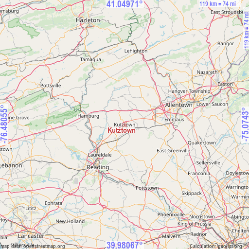
Kutztown GPS coordinates[2]
40° 31' 2.352" North, 75° 46' 38.712" West
| Map corner | latitude | longitude |
|---|---|---|
| Upper-left | 41.04971°, | -76.48055° |
| Center: | 40.51732°, | -75.77742° |
| Lower-right: | 39.98067°, | -75.0743° |
| Map W x H: | 118.9×118.9 km | = 73.9×73.9mi |
| max Lat: | 71.29058° ⇑40.9% North |
| Kutztown: | 40.51732° |
| min Lat: | ⇓59.1% South 19.06759° |
| min Long | Kutztown | max Long |
| -171.73463° | -75.77742° | -66.98998° |
| W 84.8%⇐ | ⇒15.2% E |
Elevation
Elevation of Kutztown is 131 m = 430 ft, and this is 163.8 m = 537 ft below average elevation for this country.
| Max E: |
3189 m = 10463 ft | 64.4% |
| Avg. | 294.8 m = 967 ft | |
| Kutztown | 131 m = 430 ft | |
Min E: |
-60 m = -197 ft | 35.6% |
See also: United States elevation on elevation.city.
Geographical zone
Kutztown is located in North temperate zone (between Tropic of Cancer and the Arctic Circle). Distance of this Northern Tropic circle is 1899.2 km =1180.1 mi to South.| Distance of | km | miles | from Kutztown |
|---|---|---|---|
| North Pole | 5502 | 3418.8 | to North |
| Arctic Circle | 2896.1 | 1799.6 | to North |
| Tropic Cancer | 1899.2 | 1180.1 | to South |
| Equator | 4505.1 | 2799.3 | to South |


Nearby cities:
15 places around Kutztown: (largest is in red/bold)
• Alburtis
14.8 km =9.2 mi,  92°
92°
• Ancient Oaks
16.2 km =10.1 mi,  78°
78°
• Blandon
12.5 km =7.8 mi,  227°
227°
• Breinigsville
12.5 km =7.8 mi, 80°
• Edenburg
16.4 km =10.2 mi,  289°
289°
• Fleetwood
7.8 km =4.8 mi,  205°
205°
• Mertztown
9.5 km =5.9 mi,  97°
97°
• New Jerusalem
8.1 km =5 mi,  161°
161°
• Oley
14.5 km =9 mi,  184°
184°
• Red Lion
14.2 km =8.8 mi,  106°
106°
• Shoemakersville
16.4 km =10.2 mi,  263°
263°
• South Temple
16.7 km =10.4 mi,  218°
218°
• Temple
17.2 km =10.7 mi, 225°
• Topton
6.6 km =4.1 mi, 103°
• Trexlertown
14.9 km =9.3 mi, 76°
Sources, notices
• [Note1] Compared only with cities in United States existing in our database
• [Src1] Map data: © OpenStreetMap contributors (CC-BY-SA)
• [Src2] Other city data from geonames.org with taken over terms of usage.
• [Src3] Geographical zone / Annual Mean Temperature by Robert A. Rohde @ Wikipedia
