Laporte geodata
Laporte (Pennsylvania) is a seat of a second-order administrative division; located in United States in America/New_York (GMT-4) time zone. With population of 307 people, there are 20972 cities with bigger population in this country. Compared to other cities in United States, 70% of cities are located further ↓South; 82.6% of cities are located further ←West and 89.7% of cities have lower elevation than Laporte. Note1
Administrative division(s):
- Level 1: Pennsylvania
- Level 2: Sullivan County
- Level 3: Borough of Laporte


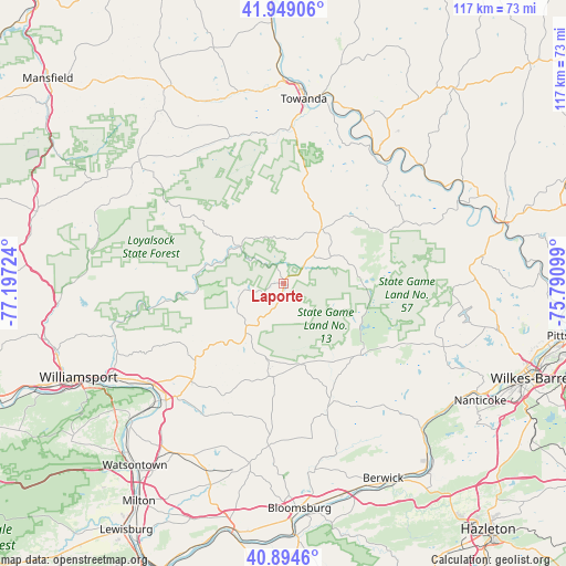
Laporte GPS coordinates[2]
41° 25' 26.292" North, 76° 29' 38.796" West
| Map corner | latitude | longitude |
|---|---|---|
| Upper-left | 41.94906°, | -77.19724° |
| Center: | 41.42397°, | -76.49411° |
| Lower-right: | 40.8946°, | -75.79099° |
| Map W x H: | 117.2×117.2 km | = 72.8×72.8mi |
| max Lat: | 71.29058° ⇑30% North |
| Laporte: | 41.42397° |
| min Lat: | ⇓70% South 19.06759° |
| min Long | Laporte | max Long |
| -171.73463° | -76.49411° | -66.98998° |
| W 82.6%⇐ | ⇒17.4% E |
Elevation
Elevation of Laporte is 600 m = 1969 ft, and this is 305.2 m = 1001 ft above average elevation for this country.
| Max E: |
3189 m = 10463 ft | 10.3% |
| Laporte | 600 m 1969 ft | |
| Avg. | 294.8 m = 967 ft | |
Min E: |
-60 m = -197 ft | 89.7% |
See also: United States elevation on elevation.city.
Geographical zone
Laporte is located in North temperate zone (between Tropic of Cancer and the Arctic Circle). Distance of this Northern Tropic circle is 2000 km =1242.7 mi to South.| Distance of | km | miles | from Laporte |
|---|---|---|---|
| North Pole | 5401.1 | 3356.1 | to North |
| Arctic Circle | 2795.3 | 1736.9 | to North |
| Tropic Cancer | 2000 | 1242.7 | to South |
| Equator | 4605.9 | 2862 | to South |


Nearby cities:
15 places around Laporte: (largest is in red/bold)
• Benton
27.1 km =16.8 mi,  160°
160°
• Canton
39.5 km =24.5 mi,  310°
310°
• Dushore
13.6 km =8.5 mi,  34°
34°
• Harveys Lake
39.4 km =24.5 mi,  96°
96°
• Hughesville
27.9 km =17.3 mi,  223°
223°
• Millville
33.9 km =21.1 mi,  185°
185°
• Monroeton
32.1 km =19.9 mi,  2°
2°
• Montoursville
40.3 km =25 mi,  242°
242°
• Muncy
34.4 km =21.4 mi,  225°
225°
• Noxen
36.3 km =22.6 mi,  90°
90°
• Orangeville
39 km =24.2 mi,  170°
170°
• Picture Rocks
24.3 km =15.1 mi, 228°
• Silkworth
38 km =23.6 mi,  116°
116°
• Towanda
38.4 km =23.9 mi,  6°
6°
• Wyalusing
33.3 km =20.7 mi,  35°
35°
Sources, notices
• [Note1] Compared only with cities in United States existing in our database
• [Src1] Map data: © OpenStreetMap contributors (CC-BY-SA)
• [Src2] Other city data from geonames.org with taken over terms of usage.
• [Src3] Geographical zone / Annual Mean Temperature by Robert A. Rohde @ Wikipedia
