Scranton geodata
Scranton (Pennsylvania) is a seat of a second-order administrative division; located in United States in America/New_York (GMT-4) time zone. With population of 77,118 people, there are 518 cities with bigger population in this country. Compared to other cities in United States, 69.8% of cities are located further ↓South; 85.1% of cities are located further ←West and 59.6% of cities have lower elevation than Scranton. Note1
Administrative division(s):
- Level 1: Pennsylvania
- Level 2: Lackawanna County
- Level 3: City of Scranton


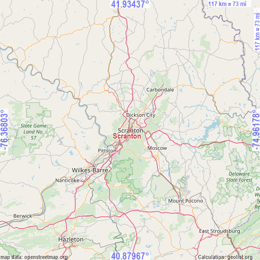
Scranton GPS coordinates[2]
41° 24' 32.976" North, 75° 39' 53.64" West
| Map corner | latitude | longitude |
|---|---|---|
| Upper-left | 41.93437°, | -76.36803° |
| Center: | 41.40916°, | -75.6649° |
| Lower-right: | 40.87967°, | -74.96178° |
| Map W x H: | 117.3×117.3 km | = 72.9×72.9mi |
| max Lat: | 71.29058° ⇑30.2% North |
| Scranton: | 41.40916° |
| min Lat: | ⇓69.8% South 19.06759° |
| min Long | Scranton | max Long |
| -171.73463° | -75.6649° | -66.98998° |
| W 85.1%⇐ | ⇒14.9% E |
Elevation
Elevation of Scranton is 238 m = 781 ft, and this is 56.8 m = 186 ft below average elevation for this country.
| Max E: |
3189 m = 10463 ft | 40.4% |
| Avg. | 294.8 m = 967 ft | |
| Scranton | 238 m = 781 ft | |
Min E: |
-60 m = -197 ft | 59.6% |
See also: Scranton elevation on elevation.city.
Geographical zone
Scranton is located in North temperate zone (between Tropic of Cancer and the Arctic Circle). Distance of this Northern Tropic circle is 1998.3 km =1241.7 mi to South.| Distance of | km | miles | from Scranton |
|---|---|---|---|
| North Pole | 5402.8 | 3357.1 | to North |
| Arctic Circle | 2796.9 | 1737.9 | to North |
| Tropic Cancer | 1998.3 | 1241.7 | to South |
| Equator | 4604.3 | 2861 | to South |


Nearby cities:
15 places around Scranton: (largest is in red/bold)
• Avoca
9.7 km =6 mi,  217°
217°
• Blakely
9.9 km =6.2 mi,  36°
36°
• Chinchilla
7.4 km =4.6 mi,  352°
352°
• Clarks Green
9.7 km =6 mi,  342°
342°
• Clarks Summit
9.6 km =6 mi, 337°
• Dickson City
8.4 km =5.2 mi,  34°
34°
• Dunmore
3 km =1.9 mi,  66°
66°
• Dupont
11.5 km =7.1 mi, 215°
• Duryea
9.5 km =5.9 mi, 220°
• Jessup
10.8 km =6.7 mi,  52°
52°
• Moosic
8.7 km =5.4 mi, 224°
• Old Forge
7.2 km =4.5 mi,  234°
234°
• Olyphant
8.4 km =5.2 mi, 38°
• Taylor
3.8 km =2.4 mi,  245°
245°
• Throop
6.5 km =4 mi, 43°
Sources, notices
• [Note1] Compared only with cities in United States existing in our database
• [Src1] Map data: © OpenStreetMap contributors (CC-BY-SA)
• [Src2] Other city data from geonames.org with taken over terms of usage.
• [Src3] Geographical zone / Annual Mean Temperature by Robert A. Rohde @ Wikipedia
