Throop geodata
Throop (Pennsylvania) is a populated place; located in United States in America/New_York (GMT-4) time zone. With population of 3,960 people, there are 8262 cities with bigger population in this country. Compared to other cities in United States, 70.3% of cities are located further ↓South; 85.2% of cities are located further ←West and 63.9% of cities have lower elevation than Throop. Note1
Administrative division(s):
- Level 1: Pennsylvania
- Level 2: Lackawanna County
- Level 3: Borough of Throop


Throop GPS coordinates[2]
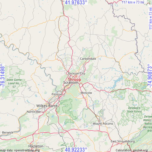
41° 27' 5.292" North, 75° 36' 42.66" West
| Map corner | latitude | longitude |
|---|---|---|
| Upper-left | 41.97633°, | -76.31498° |
| Center: | 41.45147°, | -75.61185° |
| Lower-right: | 40.92233°, | -74.90873° |
| Map W x H: | 117.2×117.2 km | = 72.8×72.8mi |
| max Lat: | 71.29058° ⇑29.7% North |
| Throop: | 41.45147° |
| min Lat: | ⇓70.3% South 19.06759° |
| min Long | Throop | max Long |
| -171.73463° | -75.61185° | -66.98998° |
| W 85.2%⇐ | ⇒14.8% E |
Elevation
Elevation of Throop is 257 m = 843 ft, and this is 37.8 m = 124 ft below average elevation for this country.
| Max E: |
3189 m = 10463 ft | 36.1% |
| Avg. | 294.8 m = 967 ft | |
| Throop | 257 m = 843 ft | |
Min E: |
-60 m = -197 ft | 63.9% |
See also: United States elevation on elevation.city.
Geographical zone
Throop is located in North temperate zone (between Tropic of Cancer and the Arctic Circle). Distance of this Northern Tropic circle is 2003.1 km =1244.7 mi to South.| Distance of | km | miles | from Throop |
|---|---|---|---|
| North Pole | 5398.1 | 3354.2 | to North |
| Arctic Circle | 2792.2 | 1735 | to North |
| Tropic Cancer | 2003.1 | 1244.7 | to South |
| Equator | 4609 | 2863.9 | to South |


Nearby cities:
15 places around Throop: (largest is in red/bold)
• Archbald
7.9 km =4.9 mi,  52°
52°
• Blakely
3.6 km =2.2 mi,  23°
23°
• Chinchilla
6 km =3.7 mi,  295°
295°
• Clarks Green
8.6 km =5.3 mi, 302°
• Clarks Summit
9.1 km =5.7 mi, 297°
• Dickson City
2.3 km =1.4 mi,  8°
8°
• Dunmore
3.9 km =2.4 mi,  205°
205°
• Jermyn
10.4 km =6.5 mi,  32°
32°
• Jessup
4.6 km =2.9 mi,  65°
65°
• Mayfield
11.5 km =7.1 mi, 33°
• Mount Cobb
10.8 km =6.7 mi,  113°
113°
• Olyphant
2 km =1.2 mi, 21°
• Scranton
6.5 km =4 mi,  223°
223°
• Taylor
10.1 km =6.3 mi,  231°
231°
• Waverly
11.4 km =7.1 mi,  316°
316°
Sources, notices
• [Note1] Compared only with cities in United States existing in our database
• [Src1] Map data: © OpenStreetMap contributors (CC-BY-SA)
• [Src2] Other city data from geonames.org with taken over terms of usage.
• [Src3] Geographical zone / Annual Mean Temperature by Robert A. Rohde @ Wikipedia
