North Scituate geodata
North Scituate (Rhode Island) is a populated place; located in United States in America/New_York (GMT-4) time zone. With population of 11,171 people, there are 4132 cities with bigger population in this country. Compared to other cities in United States, 74.2% of cities are located further ↓South; 96.4% of cities are located further ←West and 70.9% of cities have higher elevation than North Scituate. Note1
Administrative division(s):
- Level 1: Rhode Island
- Level 2: Providence County
- Level 3: Town of Scituate


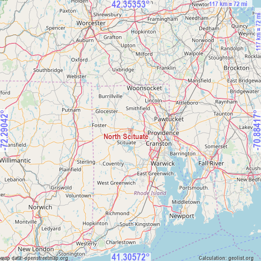
North Scituate GPS coordinates[2]
41° 49' 54.372" North, 71° 35' 14.244" West
| Map corner | latitude | longitude |
|---|---|---|
| Upper-left | 42.35353°, | -72.29042° |
| Center: | 41.83177°, | -71.58729° |
| Lower-right: | 41.30572°, | -70.88417° |
| Map W x H: | 116.5×116.5 km | = 72.4×72.4mi |
| max Lat: | 71.29058° ⇑25.8% North |
| North Scituate: | 41.83177° |
| min Lat: | ⇓74.2% South 19.06759° |
| min Long | North Scituate | max Long |
| -171.73463° | -71.58729° | -66.98998° |
| W 96.4%⇐ | ⇒3.6% E |
Elevation
Elevation of North Scituate is 95 m = 312 ft, and this is 199.8 m = 656 ft below average elevation for this country.
| Max E: |
3189 m = 10463 ft | 70.9% |
| Avg. | 294.8 m = 967 ft | |
| North Scituate | 95 m = 312 ft | |
Min E: |
-60 m = -197 ft | 29.1% |
See also: United States elevation on elevation.city.
Geographical zone
North Scituate is located in North temperate zone (between Tropic of Cancer and the Arctic Circle). Distance of this Northern Tropic circle is 2045.3 km =1270.9 mi to South.| Distance of | km | miles | from North Scituate |
|---|---|---|---|
| North Pole | 5355.8 | 3327.9 | to North |
| Arctic Circle | 2749.9 | 1708.7 | to North |
| Tropic Cancer | 2045.3 | 1270.9 | to South |
| Equator | 4651.3 | 2890.2 | to South |


Nearby cities:
15 places around North Scituate: (largest is in red/bold)
• Chepachet
11.6 km =7.2 mi,  323°
323°
• Coventry
16.6 km =10.3 mi,  208°
208°
• Cranston
13.7 km =8.5 mi,  114°
114°
• Foster
14.4 km =8.9 mi,  279°
279°
• Greenville
5.3 km =3.3 mi,  33°
33°
• Harmony
6.3 km =3.9 mi,  352°
352°
• Harrisville
16.5 km =10.3 mi,  334°
334°
• Johnston
6.8 km =4.2 mi,  99°
99°
• Lincoln
16.1 km =10 mi,  51°
51°
• North Providence
10.2 km =6.3 mi,  78°
78°
• North Smithfield
15.3 km =9.5 mi,  11°
11°
• Pascoag
16.7 km =10.4 mi, 325°
• Providence
14.5 km =9 mi,  93°
93°
• Smithfield
10.5 km =6.5 mi,  17°
17°
• West Warwick
15.9 km =9.9 mi,  160°
160°
Sources, notices
• [Note1] Compared only with cities in United States existing in our database
• [Src1] Map data: © OpenStreetMap contributors (CC-BY-SA)
• [Src2] Other city data from geonames.org with taken over terms of usage.
• [Src3] Geographical zone / Annual Mean Temperature by Robert A. Rohde @ Wikipedia
