Coventry geodata
Coventry (Rhode Island) is a populated place; located in United States in America/New_York (GMT-4) time zone. With population of 35,525 people, there are 1386 cities with bigger population in this country. Compared to other cities in United States, 72.9% of cities are located further ↓South; 96.2% of cities are located further ←West and 68% of cities have higher elevation than Coventry. Note1


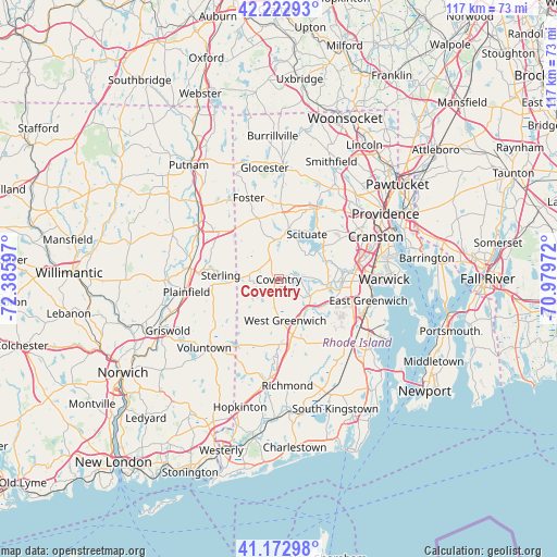
Coventry GPS coordinates[2]
41° 42' 0.36" North, 71° 40' 58.224" West
| Map corner | latitude | longitude |
|---|---|---|
| Upper-left | 42.22293°, | -72.38597° |
| Center: | 41.7001°, | -71.68284° |
| Lower-right: | 41.17298°, | -70.97972° |
| Map W x H: | 116.7×116.7 km | = 72.5×72.5mi |
| max Lat: | 71.29058° ⇑27.1% North |
| Coventry: | 41.7001° |
| min Lat: | ⇓72.9% South 19.06759° |
| min Long | Coventry | max Long |
| -171.73463° | -71.68284° | -66.98998° |
| W 96.2%⇐ | ⇒3.8% E |
Elevation
Elevation of Coventry is 112 m = 367 ft, and this is 182.8 m = 600 ft below average elevation for this country.
| Max E: |
3189 m = 10463 ft | 68% |
| Avg. | 294.8 m = 967 ft | |
| Coventry | 112 m = 367 ft | |
Min E: |
-60 m = -197 ft | 32% |
See also: United States elevation on elevation.city.
Geographical zone
Coventry is located in North temperate zone (between Tropic of Cancer and the Arctic Circle). Distance of this Northern Tropic circle is 2030.7 km =1261.8 mi to South.| Distance of | km | miles | from Coventry |
|---|---|---|---|
| North Pole | 5370.4 | 3337 | to North |
| Arctic Circle | 2764.6 | 1717.8 | to North |
| Tropic Cancer | 2030.7 | 1261.8 | to South |
| Equator | 4636.6 | 2881 | to South |


Nearby cities:
15 places around Coventry: (largest is in red/bold)
• Danielson
20.3 km =12.6 mi,  304°
304°
• East Brooklyn
20.8 km =12.9 mi, 301°
• East Greenwich
19.4 km =12.1 mi,  103°
103°
• Exeter
18.2 km =11.3 mi,  138°
138°
• Foster
18.2 km =11.3 mi,  339°
339°
• Greene
5.3 km =3.3 mi,  259°
259°
• Hope Valley
21.6 km =13.4 mi,  187°
187°
• Johnston
19.9 km =12.4 mi,  47°
47°
• Moosup
16.5 km =10.3 mi,  274°
274°
• North Scituate
16.6 km =10.3 mi,  28°
28°
• Plainfield
19.5 km =12.1 mi, 262°
• Plainfield Village
20.3 km =12.6 mi, 262°
• Wauregan
19.4 km =12.1 mi,  284°
284°
• West Greenwich
7.3 km =4.5 mi,  164°
164°
• West Warwick
13.4 km =8.3 mi,  91°
91°
Sources, notices
• [Note1] Compared only with cities in United States existing in our database
• [Src1] Map data: © OpenStreetMap contributors (CC-BY-SA)
• [Src2] Other city data from geonames.org with taken over terms of usage.
• [Src3] Geographical zone / Annual Mean Temperature by Robert A. Rohde @ Wikipedia
