Viborg geodata
Viborg (South Dakota) is a populated place; located in United States in America/Chicago (GMT-5) time zone. With population of 762 people, there are 18109 cities with bigger population in this country. Compared to other cities in United States, 84.6% of cities are located further ↓South; 75.9% of cities are located further →East and 83.6% of cities have lower elevation than Viborg. Note1


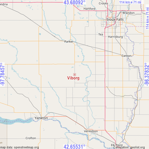
Viborg GPS coordinates[2]
43° 10' 12.972" North, 97° 4' 53.184" West
| Map corner | latitude | longitude |
|---|---|---|
| Upper-left | 43.68092°, | -97.78457° |
| Center: | 43.17027°, | -97.08144° |
| Lower-right: | 42.65531°, | -96.37832° |
| Map W x H: | 114×114 km | = 70.8×70.8mi |
| max Lat: | 71.29058° ⇑15.4% North |
| Viborg: | 43.17027° |
| min Lat: | ⇓84.6% South 19.06759° |
| min Long | Viborg | max Long |
| -171.73463° | -97.08144° | -66.98998° |
| W 24.1%⇐ | ⇒75.9% E |
Elevation
Elevation of Viborg is 398 m = 1306 ft, and this is 103.2 m = 339 ft above average elevation for this country.
| Max E: |
3189 m = 10463 ft | 16.4% |
| Viborg | 398 m 1306 ft | |
| Avg. | 294.8 m = 967 ft | |
Min E: |
-60 m = -197 ft | 83.6% |
See also: United States elevation on elevation.city.
Geographical zone
Viborg is located in North temperate zone (between Tropic of Cancer and the Arctic Circle). Distance of this Northern Tropic circle is 2194.2 km =1363.4 mi to South.| Distance of | km | miles | from Viborg |
|---|---|---|---|
| North Pole | 5207 | 3235.5 | to North |
| Arctic Circle | 2601.1 | 1616.2 | to North |
| Tropic Cancer | 2194.2 | 1363.4 | to South |
| Equator | 4800.1 | 2982.6 | to South |


Nearby cities:
15 places around Viborg: (largest is in red/bold)
• Alcester
40.2 km =25 mi,  114°
114°
• Beresford
26.9 km =16.7 mi, 111°
• Canton
42.2 km =26.2 mi,  69°
69°
• Centerville
11.3 km =7 mi,  120°
120°
• Freeman
35.2 km =21.9 mi,  305°
305°
• Harrisburg
42.5 km =26.4 mi,  46°
46°
• Lennox
25.6 km =15.9 mi,  36°
36°
• Marion
31.6 km =19.6 mi,  332°
332°
• Menno
41 km =25.5 mi,  280°
280°
• Parker
25.7 km =16 mi,  350°
350°
• Shindler
48.7 km =30.3 mi, 45°
• Tea
36.6 km =22.7 mi,  32°
32°
• Vermillion
45.2 km =28.1 mi,  164°
164°
• Worthing
31.3 km =19.4 mi,  55°
55°
• Yankton
42 km =26.1 mi,  217°
217°
Sources, notices
• [Note1] Compared only with cities in United States existing in our database
• [Src1] Map data: © OpenStreetMap contributors (CC-BY-SA)
• [Src2] Other city data from geonames.org with taken over terms of usage.
• [Src3] Geographical zone / Annual Mean Temperature by Robert A. Rohde @ Wikipedia
