Milbank geodata
Milbank (South Dakota) is a seat of a second-order administrative division; located in United States in America/Chicago (GMT-5) time zone. With population of 3,192 people, there are 9312 cities with bigger population in this country. Compared to other cities in United States, 93.2% of cities are located further ↓South; 74.8% of cities are located further →East and 79.8% of cities have lower elevation than Milbank. Note1


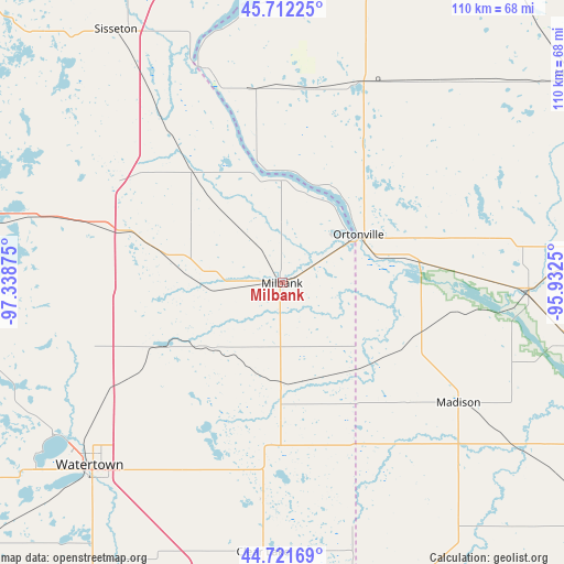
Milbank GPS coordinates[2]
45° 13' 8.868" North, 96° 38' 8.232" West
| Map corner | latitude | longitude |
|---|---|---|
| Upper-left | 45.71225°, | -97.33875° |
| Center: | 45.21913°, | -96.63562° |
| Lower-right: | 44.72169°, | -95.9325° |
| Map W x H: | 110.1×110.1 km | = 68.4×68.4mi |
| max Lat: | 71.29058° ⇑6.8% North |
| Milbank: | 45.21913° |
| min Lat: | ⇓93.2% South 19.06759° |
| min Long | Milbank | max Long |
| -171.73463° | -96.63562° | -66.98998° |
| W 25.2%⇐ | ⇒74.8% E |
Elevation
Elevation of Milbank is 351 m = 1152 ft, and this is 56.2 m = 184 ft above average elevation for this country.
| Max E: |
3189 m = 10463 ft | 20.2% |
| Milbank | 351 m 1152 ft | |
| Avg. | 294.8 m = 967 ft | |
Min E: |
-60 m = -197 ft | 79.8% |
See also: United States elevation on elevation.city.
Geographical zone
Milbank is located in North temperate zone (between Tropic of Cancer and the Arctic Circle). Distance of this North polar circle is 2373.3 km =1474.7 mi to North.| Distance of | km | miles | from Milbank |
|---|---|---|---|
| North Pole | 4979.2 | 3093.9 | to North |
| Arctic Circle | 2373.3 | 1474.7 | to North |
| Tropic Cancer | 2422 | 1505 | to South |
| Equator | 5027.9 | 3124.2 | to South |


Nearby cities:
15 places around Milbank: (largest is in red/bold)
• Appleton
48.3 km =30 mi,  92°
92°
• Browns Valley
44.6 km =27.7 mi,  339°
339°
• Canby
63.4 km =39.4 mi,  153°
153°
• Castlewood
63.3 km =39.3 mi,  209°
209°
• Clear Lake
52.8 km =32.8 mi,  184°
184°
• Dawson
55.6 km =34.5 mi,  124°
124°
• Goodwill
51.4 km =31.9 mi,  318°
318°
• Graceville
42 km =26.1 mi,  21°
21°
• Madison
41.6 km =25.8 mi, 124°
• Ortonville
17.7 km =11 mi,  57°
57°
• Sisseton
59.1 km =36.7 mi,  326°
326°
• Watertown
51.8 km =32.2 mi,  226°
226°
• Waubay
53.9 km =33.5 mi,  283°
283°
• Wheaton
65.9 km =40.9 mi,  9°
9°
• Wilmot
27.3 km =17 mi, 320°
Sources, notices
• [Note1] Compared only with cities in United States existing in our database
• [Src1] Map data: © OpenStreetMap contributors (CC-BY-SA)
• [Src2] Other city data from geonames.org with taken over terms of usage.
• [Src3] Geographical zone / Annual Mean Temperature by Robert A. Rohde @ Wikipedia
