Browns Valley geodata
Browns Valley (Minnesota) is a populated place; located in United States in America/Chicago (GMT-5) time zone. With population of 557 people, there are 20192 cities with bigger population in this country. Compared to other cities in United States, 94.3% of cities are located further ↓South; 75.3% of cities are located further →East and 72% of cities have lower elevation than Browns Valley. Note1
Administrative division(s):
- Level 1: Minnesota
- Level 2: Traverse County
- Level 3: City of Browns Valley


Browns Valley GPS coordinates[2]
45° 35' 42.864" North, 96° 50' 0.276" West
| Map corner | latitude | longitude |
|---|---|---|
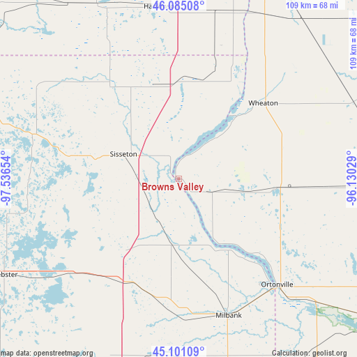
| Upper-left | 46.08508°, | -97.53654° |
| Center: | 45.59524°, | -96.83341° |
| Lower-right: | 45.10109°, | -96.13029° |
| Map W x H: | 109.4×109.4 km | = 68×68mi |
| max Lat: | 71.29058° ⇑5.7% North |
| Browns Valley: | 45.59524° |
| min Lat: | ⇓94.3% South 19.06759° |
| min Long | Browns Valley | max Long |
| -171.73463° | -96.83341° | -66.98998° |
| W 24.7%⇐ | ⇒75.3% E |
Elevation
Elevation of Browns Valley is 296 m = 971 ft, and this is 1.2 m = 4 ft above average elevation for this country.
| Max E: |
3189 m = 10463 ft | 28% |
| Browns Valley | 296 m 971 ft | |
| Avg. | 294.8 m = 967 ft | |
Min E: |
-60 m = -197 ft | 72% |
See also: United States elevation on elevation.city.
Geographical zone
Browns Valley is located in North temperate zone (between Tropic of Cancer and the Arctic Circle). Distance of this North polar circle is 2331.5 km =1448.7 mi to North.| Distance of | km | miles | from Browns Valley |
|---|---|---|---|
| North Pole | 4937.3 | 3067.9 | to North |
| Arctic Circle | 2331.5 | 1448.7 | to North |
| Tropic Cancer | 2463.8 | 1530.9 | to South |
| Equator | 5069.7 | 3150.2 | to South |


Nearby cities:
15 places around Browns Valley: (largest is in red/bold)
• Britton
74.5 km =46.3 mi,  287°
287°
• Goodwill
18.7 km =11.6 mi,  260°
260°
• Graceville
31.2 km =19.4 mi,  95°
95°
• Hankinson
53 km =32.9 mi,  354°
354°
• Lidgerwood
58.8 km =36.5 mi,  335°
335°
• Milbank
44.6 km =27.7 mi,  159°
159°
• Morris
71.5 km =44.4 mi,  90°
90°
• Ortonville
44.3 km =27.5 mi,  136°
136°
• Sisseton
18.5 km =11.5 mi, 294°
• Veblen
46.1 km =28.6 mi,  310°
310°
• Wahpeton
76.5 km =47.5 mi,  13°
13°
• Waubay
47 km =29.2 mi,  231°
231°
• Webster
61 km =37.9 mi,  241°
241°
• Wheaton
34.8 km =21.6 mi,  48°
48°
• Wilmot
20.8 km =12.9 mi,  185°
185°
Sources, notices
• [Note1] Compared only with cities in United States existing in our database
• [Src1] Map data: © OpenStreetMap contributors (CC-BY-SA)
• [Src2] Other city data from geonames.org with taken over terms of usage.
• [Src3] Geographical zone / Annual Mean Temperature by Robert A. Rohde @ Wikipedia
