Goodwill geodata
Goodwill (South Dakota) is a populated place; located in United States in America/Chicago (GMT-5) time zone. With population of 513 people, there are 20718 cities with bigger population in this country. Compared to other cities in United States, 94.2% of cities are located further ↓South; 75.9% of cities are located further →East and 86.8% of cities have lower elevation than Goodwill. Note1
Administrative division(s):
- Level 1: South Dakota
- Level 2: Roberts County
- Level 3: Township of Goodwill


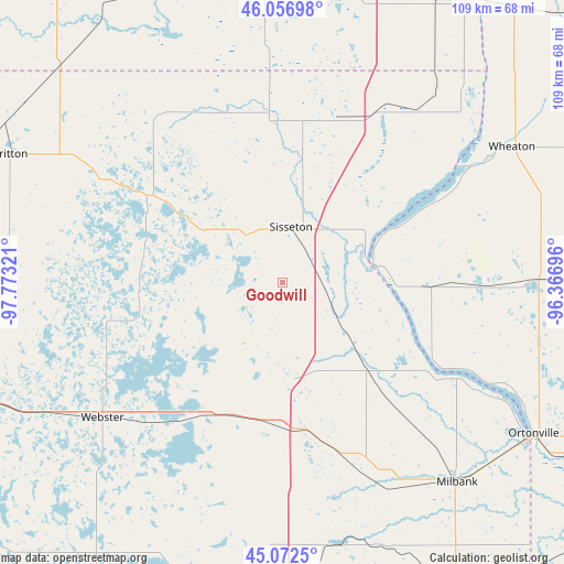
Goodwill GPS coordinates[2]
45° 34' 0.84" North, 97° 4' 12.288" West
| Map corner | latitude | longitude |
|---|---|---|
| Upper-left | 46.05698°, | -97.77321° |
| Center: | 45.5669°, | -97.07008° |
| Lower-right: | 45.0725°, | -96.36696° |
| Map W x H: | 109.5×109.5 km | = 68×68mi |
| max Lat: | 71.29058° ⇑5.8% North |
| Goodwill: | 45.5669° |
| min Lat: | ⇓94.2% South 19.06759° |
| min Long | Goodwill | max Long |
| -171.73463° | -97.07008° | -66.98998° |
| W 24.1%⇐ | ⇒75.9% E |
Elevation
Elevation of Goodwill is 462 m = 1516 ft, and this is 167.2 m = 549 ft above average elevation for this country.
| Max E: |
3189 m = 10463 ft | 13.2% |
| Goodwill | 462 m 1516 ft | |
| Avg. | 294.8 m = 967 ft | |
Min E: |
-60 m = -197 ft | 86.8% |
See also: United States elevation on elevation.city.
Geographical zone
Goodwill is located in North temperate zone (between Tropic of Cancer and the Arctic Circle). Distance of this North polar circle is 2334.6 km =1450.7 mi to North.| Distance of | km | miles | from Goodwill |
|---|---|---|---|
| North Pole | 4940.5 | 3069.9 | to North |
| Arctic Circle | 2334.6 | 1450.7 | to North |
| Tropic Cancer | 2460.6 | 1528.9 | to South |
| Equator | 5066.6 | 3148.2 | to South |


Nearby cities:
15 places around Goodwill: (largest is in red/bold)
• Britton
58.5 km =36.4 mi,  295°
295°
• Browns Valley
18.7 km =11.6 mi,  80°
80°
• Forman
74.4 km =46.2 mi,  323°
323°
• Graceville
49.5 km =30.8 mi,  89°
89°
• Hankinson
57.4 km =35.7 mi,  13°
13°
• Lidgerwood
56.9 km =35.4 mi,  353°
353°
• Milbank
51.4 km =31.9 mi,  138°
138°
• Ortonville
56.8 km =35.3 mi,  120°
120°
• Sisseton
11 km =6.8 mi, 8°
• Veblen
37 km =23 mi,  332°
332°
• Watertown
74.3 km =46.2 mi,  182°
182°
• Waubay
31.9 km =19.8 mi,  215°
215°
• Webster
43.7 km =27.2 mi,  233°
233°
• Wheaton
51.6 km =32.1 mi,  59°
59°
• Wilmot
24.2 km =15 mi, 136°
Sources, notices
• [Note1] Compared only with cities in United States existing in our database
• [Src1] Map data: © OpenStreetMap contributors (CC-BY-SA)
• [Src2] Other city data from geonames.org with taken over terms of usage.
• [Src3] Geographical zone / Annual Mean Temperature by Robert A. Rohde @ Wikipedia
