Wheaton geodata
Wheaton (Minnesota) is a seat of a second-order administrative division; located in United States in America/Chicago (GMT-5) time zone. With population of 1,362 people, there are 14295 cities with bigger population in this country. Compared to other cities in United States, 94.8% of cities are located further ↓South; 74.5% of cities are located further →East and 74.7% of cities have lower elevation than Wheaton. Note1


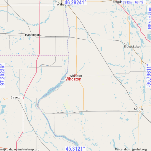
Wheaton GPS coordinates[2]
45° 48' 15.876" North, 96° 29' 57.228" West
| Map corner | latitude | longitude |
|---|---|---|
| Upper-left | 46.29241°, | -97.20236° |
| Center: | 45.80441°, | -96.49923° |
| Lower-right: | 45.3121°, | -95.79611° |
| Map W x H: | 109×109 km | = 67.7×67.7mi |
| max Lat: | 71.29058° ⇑5.2% North |
| Wheaton: | 45.80441° |
| min Lat: | ⇓94.8% South 19.06759° |
| min Long | Wheaton | max Long |
| -171.73463° | -96.49923° | -66.98998° |
| W 25.5%⇐ | ⇒74.5% E |
Elevation
Elevation of Wheaton is 311 m = 1020 ft, and this is 16.2 m = 53 ft above average elevation for this country.
| Max E: |
3189 m = 10463 ft | 25.3% |
| Wheaton | 311 m 1020 ft | |
| Avg. | 294.8 m = 967 ft | |
Min E: |
-60 m = -197 ft | 74.7% |
See also: United States elevation on elevation.city.
Geographical zone
Wheaton is located in North temperate zone (between Tropic of Cancer and the Arctic Circle). Distance of this North polar circle is 2308.2 km =1434.2 mi to North.| Distance of | km | miles | from Wheaton |
|---|---|---|---|
| North Pole | 4914.1 | 3053.5 | to North |
| Arctic Circle | 2308.2 | 1434.2 | to North |
| Tropic Cancer | 2487.1 | 1545.4 | to South |
| Equator | 5093 | 3164.6 | to South |


Nearby cities:
15 places around Wheaton: (largest is in red/bold)
• Breckenridge
51.5 km =32 mi,  352°
352°
• Browns Valley
34.8 km =21.6 mi,  228°
228°
• Elbow Lake
45.6 km =28.3 mi,  62°
62°
• Fergus Falls
62.4 km =38.8 mi,  31°
31°
• Goodwill
51.6 km =32.1 mi,  239°
239°
• Graceville
26.6 km =16.5 mi,  169°
169°
• Hankinson
42.9 km =26.7 mi,  313°
313°
• Hoffman
54.9 km =34.1 mi,  87°
87°
• Lidgerwood
58.8 km =36.5 mi,  300°
300°
• Morris
51.5 km =32 mi,  118°
118°
• Ortonville
55.7 km =34.6 mi,  175°
175°
• Sisseton
45.5 km =28.3 mi,  250°
250°
• Veblen
61.4 km =38.2 mi,  276°
276°
• Wahpeton
51.9 km =32.2 mi, 350°
• Wilmot
52.1 km =32.4 mi,  212°
212°
Sources, notices
• [Note1] Compared only with cities in United States existing in our database
• [Src1] Map data: © OpenStreetMap contributors (CC-BY-SA)
• [Src2] Other city data from geonames.org with taken over terms of usage.
• [Src3] Geographical zone / Annual Mean Temperature by Robert A. Rohde @ Wikipedia
