Footville geodata
Footville (Wisconsin) is a populated place; located in United States in America/Chicago (GMT-5) time zone. With population of 804 people, there are 17772 cities with bigger population in this country. Compared to other cities in United States, 81% of cities are located further ↓South; 56.7% of cities are located further →East and 63.7% of cities have lower elevation than Footville. Note1


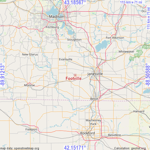
Footville GPS coordinates[2]
42° 40' 15.024" North, 89° 12' 32.4" West
| Map corner | latitude | longitude |
|---|---|---|
| Upper-left | 43.18567°, | -89.91213° |
| Center: | 42.67084°, | -89.209° |
| Lower-right: | 42.15171°, | -88.50588° |
| Map W x H: | 115×115 km | = 71.5×71.5mi |
| max Lat: | 71.29058° ⇑19% North |
| Footville: | 42.67084° |
| min Lat: | ⇓81% South 19.06759° |
| min Long | Footville | max Long |
| -171.73463° | -89.209° | -66.98998° |
| W 43.3%⇐ | ⇒56.7% E |
Elevation
Elevation of Footville is 256 m = 840 ft, and this is 38.8 m = 127 ft below average elevation for this country.
| Max E: |
3189 m = 10463 ft | 36.3% |
| Avg. | 294.8 m = 967 ft | |
| Footville | 256 m = 840 ft | |
Min E: |
-60 m = -197 ft | 63.7% |
See also: United States elevation on elevation.city.
Geographical zone
Footville is located in North temperate zone (between Tropic of Cancer and the Arctic Circle). Distance of this Northern Tropic circle is 2138.6 km =1328.9 mi to South.| Distance of | km | miles | from Footville |
|---|---|---|---|
| North Pole | 5262.5 | 3270 | to North |
| Arctic Circle | 2656.6 | 1650.7 | to North |
| Tropic Cancer | 2138.6 | 1328.9 | to South |
| Equator | 4744.6 | 2948.2 | to South |


Nearby cities:
15 places around Footville: (largest is in red/bold)
• Albany
19.1 km =11.9 mi,  282°
282°
• Beloit
23.2 km =14.4 mi,  141°
141°
• Brodhead
14.9 km =9.3 mi,  246°
246°
• Brooklyn
24.2 km =15 mi,  327°
327°
• Decatur
17.1 km =10.6 mi,  256°
256°
• Durand
27.9 km =17.3 mi,  201°
201°
• Edgerton
21.6 km =13.4 mi,  32°
32°
• Evansville
14.2 km =8.8 mi, 328°
• Janesville
15.6 km =9.7 mi,  85°
85°
• Milton
24.6 km =15.3 mi,  61°
61°
• Orfordville
6 km =3.7 mi,  216°
216°
• Rockton
26.7 km =16.6 mi,  155°
155°
• Rutland
25.8 km =16 mi, 333°
• South Beloit
24.3 km =15.1 mi, 144°
• Stoughton
27.4 km =17 mi,  358°
358°
Sources, notices
• [Note1] Compared only with cities in United States existing in our database
• [Src1] Map data: © OpenStreetMap contributors (CC-BY-SA)
• [Src2] Other city data from geonames.org with taken over terms of usage.
• [Src3] Geographical zone / Annual Mean Temperature by Robert A. Rohde @ Wikipedia
