Chilton geodata
Chilton (Wisconsin) is a seat of a second-order administrative division; located in United States in America/Chicago (GMT-5) time zone. With population of 3,896 people, there are 8330 cities with bigger population in this country. Compared to other cities in United States, 88.5% of cities are located further ↓South; 53.6% of cities are located further →East and 67.6% of cities have lower elevation than Chilton. Note1


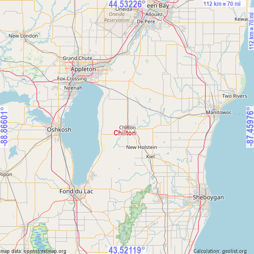
Chilton GPS coordinates[2]
44° 1' 43.968" North, 88° 9' 46.368" West
| Map corner | latitude | longitude |
|---|---|---|
| Upper-left | 44.53226°, | -88.86601° |
| Center: | 44.02888°, | -88.16288° |
| Lower-right: | 43.52119°, | -87.45976° |
| Map W x H: | 112.4×112.4 km | = 69.8×69.8mi |
| max Lat: | 71.29058° ⇑11.5% North |
| Chilton: | 44.02888° |
| min Lat: | ⇓88.5% South 19.06759° |
| min Long | Chilton | max Long |
| -171.73463° | -88.16288° | -66.98998° |
| W 46.4%⇐ | ⇒53.6% E |
Elevation
Elevation of Chilton is 274 m = 899 ft, and this is 20.8 m = 68 ft below average elevation for this country.
| Max E: |
3189 m = 10463 ft | 32.4% |
| Avg. | 294.8 m = 967 ft | |
| Chilton | 274 m = 899 ft | |
Min E: |
-60 m = -197 ft | 67.6% |
See also: United States elevation on elevation.city.
Geographical zone
Chilton is located in North temperate zone (between Tropic of Cancer and the Arctic Circle). Distance of this Northern Tropic circle is 2289.6 km =1422.7 mi to South.| Distance of | km | miles | from Chilton |
|---|---|---|---|
| North Pole | 5111.5 | 3176.1 | to North |
| Arctic Circle | 2505.6 | 1556.9 | to North |
| Tropic Cancer | 2289.6 | 1422.7 | to South |
| Equator | 4895.6 | 3042 | to South |


Nearby cities:
15 places around Chilton: (largest is in red/bold)
• Brillion
18.3 km =11.4 mi,  25°
25°
• Brothertown
13.5 km =8.4 mi,  239°
239°
• Elkhart Lake
24.6 km =15.3 mi,  151°
151°
• Forest Junction
20.5 km =12.7 mi,  4°
4°
• Hilbert
12.4 km =7.7 mi,  359°
359°
• Kiel
16.5 km =10.3 mi,  141°
141°
• Maple Grove
26.1 km =16.2 mi,  46°
46°
• Mount Calvary
23.5 km =14.6 mi,  196°
196°
• New Holstein
10.8 km =6.7 mi, 144°
• Reedsville
21.5 km =13.4 mi, 49°
• Saint Nazianz
19.4 km =12.1 mi,  96°
96°
• Saint Peter
25.7 km =16 mi,  213°
213°
• Sherwood
17.9 km =11.1 mi,  334°
334°
• Stockbridge
11.9 km =7.4 mi,  293°
293°
• Valders
22.6 km =14 mi,  79°
79°
Sources, notices
• [Note1] Compared only with cities in United States existing in our database
• [Src1] Map data: © OpenStreetMap contributors (CC-BY-SA)
• [Src2] Other city data from geonames.org with taken over terms of usage.
• [Src3] Geographical zone / Annual Mean Temperature by Robert A. Rohde @ Wikipedia
