Reedsville geodata
Reedsville (Wisconsin) is a populated place; located in United States in America/Chicago (GMT-5) time zone. With population of 1,175 people, there are 15260 cities with bigger population in this country. Compared to other cities in United States, 89% of cities are located further ↓South; 52.7% of cities are located further →East and 63.3% of cities have lower elevation than Reedsville. Note1
Administrative division(s):
- Level 1: Wisconsin
- Level 2: Manitowoc County
- Level 3: Village of Reedsville


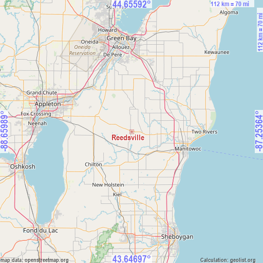
Reedsville GPS coordinates[2]
44° 9' 12.96" North, 87° 57' 24.336" West
| Map corner | latitude | longitude |
|---|---|---|
| Upper-left | 44.65592°, | -88.65989° |
| Center: | 44.1536°, | -87.95676° |
| Lower-right: | 43.64697°, | -87.25364° |
| Map W x H: | 112.2×112.2 km | = 69.7×69.7mi |
| max Lat: | 71.29058° ⇑11% North |
| Reedsville: | 44.1536° |
| min Lat: | ⇓89% South 19.06759° |
| min Long | Reedsville | max Long |
| -171.73463° | -87.95676° | -66.98998° |
| W 47.3%⇐ | ⇒52.7% E |
Elevation
Elevation of Reedsville is 254 m = 833 ft, and this is 40.8 m = 134 ft below average elevation for this country.
| Max E: |
3189 m = 10463 ft | 36.7% |
| Avg. | 294.8 m = 967 ft | |
| Reedsville | 254 m = 833 ft | |
Min E: |
-60 m = -197 ft | 63.3% |
See also: United States elevation on elevation.city.
Geographical zone
Reedsville is located in North temperate zone (between Tropic of Cancer and the Arctic Circle). Distance of this Northern Tropic circle is 2303.5 km =1431.3 mi to South.| Distance of | km | miles | from Reedsville |
|---|---|---|---|
| North Pole | 5097.6 | 3167.5 | to North |
| Arctic Circle | 2491.8 | 1548.3 | to North |
| Tropic Cancer | 2303.5 | 1431.3 | to South |
| Equator | 4909.4 | 3050.6 | to South |


Nearby cities:
15 places around Reedsville: (largest is in red/bold)
• Brillion
9 km =5.6 mi,  287°
287°
• Cato
7.7 km =4.8 mi,  98°
98°
• Chilton
21.5 km =13.4 mi,  229°
229°
• Cooperstown
22.9 km =14.2 mi,  39°
39°
• Denmark
23.9 km =14.9 mi,  25°
25°
• Forest Junction
16.3 km =10.1 mi, 293°
• Francis Creek
19.4 km =12.1 mi,  74°
74°
• Greenleaf
20.9 km =13 mi,  327°
327°
• Hilbert
16.6 km =10.3 mi,  264°
264°
• Maple Grove
4.8 km =3 mi, 33°
• New Holstein
24.8 km =15.4 mi,  204°
204°
• Saint Nazianz
16.4 km =10.2 mi,  170°
170°
• Sherwood
24.3 km =15.1 mi,  275°
275°
• Valders
11.3 km =7 mi,  149°
149°
• Whitelaw
10.8 km =6.7 mi, 95°
Sources, notices
• [Note1] Compared only with cities in United States existing in our database
• [Src1] Map data: © OpenStreetMap contributors (CC-BY-SA)
• [Src2] Other city data from geonames.org with taken over terms of usage.
• [Src3] Geographical zone / Annual Mean Temperature by Robert A. Rohde @ Wikipedia
